IMAGES TAKEN NEAR TO
Broad Oak, BRIDGNORTH, WV15 6EQ
Introduction
This page details the photographs taken nearby to Broad Oak, WV15 6EQ by members of the Geograph project.
The Geograph project started in 2005 with the aim of publishing, organising and preserving representative images for every square kilometre of Great Britain, Ireland and the Isle of Man.

There are currently over 7.5m images from over14,400 individuals and you can help contribute to the project by visiting https://www.geograph.org.uk
Image Map
Images are licensed for reuse under creativecommons.org/licenses/by-sa/2.0
Notes
- Clicking on the map will re-center to the selected point.
- The higher the marker number, the further away the image location is from the centre of the postcode.
Image Listing (11 Images Found)
Images are licensed for reuse under creativecommons.org/licenses/by-sa/2.0
Image
Details
Distance
1
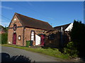
The former Broad Oak Chapel
Presumably a former Methodist Chapel, and built in 1866 according to the stone in the gable, this is now the Tuckhill Village Hall.
Image: © Richard Law
Taken: 9 Aug 2012
0.10 miles
3
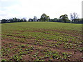
Murdeford Field
A field near Six Ashes, Shropshire.
Image: © Gordon Griffiths
Taken: 18 May 2010
0.22 miles
4
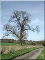
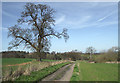
Oak tree and track north of Six Ashes, Staffordshire
The farm track is also a public footpath across fields, just inside the Shropshire boundary, to Gatacre Park.
Image: © Roger D Kidd
Taken: 25 Mar 2012
0.23 miles
5
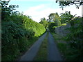
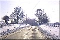
A narrow lane beside Cherry Orchard Farm
The lane runs south towards Tuckhill village.
Image: © Richard Law
Taken: 9 Aug 2012
0.24 miles
6
Farm track north of Six Ashes, Staffordshire
The route is also a public footpath across fields, just inside the Shropshire boundary, to Gatacre Park.
Image: © Roger D Kidd
Taken: 25 Mar 2012
0.24 miles
7
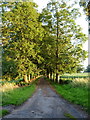
Near Gateacre Park farm
The entrance road (and bridleway) from the A458 to the farm.
Image: © Richard Law
Taken: 9 Aug 2012
0.24 miles
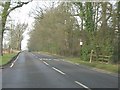
8
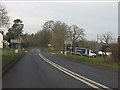
Six Ashes crossroads, A458
Beyond the junction is a sign marking the shift from Staffordshire to Shropshire.
Image: © Peter Whatley
Taken: 17 Jan 2012
0.24 miles
9
Tuck Hill, Six Ashes
The Road drops down a steep hill. Taken Circa 1963 By Hiram Meese. Submitted by his daughter, Wendy Meese.
Image: © Hiram Meese
Taken: 25 Dec 1963
0.24 miles
10
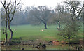
Grazing, Gatacre Park, Shropshire
Though designated "park or ornamental ground" by O.S., this idyllic area is not open to the public, except by the designated public footpaths. The undulating and oak-strewn grazing land reveals its sandstone soil origin at the pools' edges.
Image: © Roger Kidd
Taken: 30 Mar 2007
0.24 miles