IMAGES TAKEN NEAR TO
High Grosvenor, BRIDGNORTH, WV15 5PN
Introduction
This page details the photographs taken nearby to WV15 5PN by members of the Geograph project.
The Geograph project started in 2005 with the aim of publishing, organising and preserving representative images for every square kilometre of Great Britain, Ireland and the Isle of Man.

There are currently over 7.5m images from over14,400 individuals and you can help contribute to the project by visiting https://www.geograph.org.uk
Image Map
Images are licensed for reuse under creativecommons.org/licenses/by-sa/2.0
Notes
- Clicking on the map will re-center to the selected point.
- The higher the marker number, the further away the image location is from the centre of the postcode.
Image Listing (41 Images Found)
Images are licensed for reuse under creativecommons.org/licenses/by-sa/2.0
Image
Details
Distance
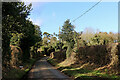
1
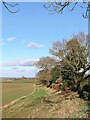
Shropshire farmland west of Claverley
Looking north near Woundale. The byway from Upper Farmcote is off to the right of the hedge.
Image: © Roger Kidd
Taken: 27 Jan 2022
0.03 miles
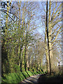
2
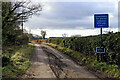
Byway to Upper Farmcote in Shropshire
The road has a stony rough surface as far as Windy Arbour (and it was breezy up there today). Beyond that it is no more than an unsurfaced track. Despite the sign, it is mapped as a "byway open to all traffic".
The other end, near the Lion o'Morfe public house: Image]
Image: © Roger Kidd
Taken: 27 Jan 2022
0.05 miles
3
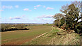
Shropshire farmland west of Claverley
Looking north near Woundale. The byway from Upper Farmcote is off to the right of the hedge.
Image: © Roger Kidd
Taken: 27 Jan 2022
0.06 miles
4
Woundale Byway
The view along the path in Shropshire.
Image: © Gordon Griffiths
Taken: 10 Oct 2016
0.07 miles
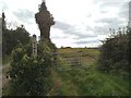
5
Lane near Woundale in Shropshire
Looking north-west towards the crossroads near High Grosvenor Farm.
Image: © Roger Kidd
Taken: 27 Jan 2022
0.07 miles
7
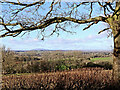
Shropshire farmland and woodland near Woundale
Looking north-west from the byway near Woundale House Farm. On the skyline, The Wrekin dominates, thirteen miles (21km) away, and 1335 feet high (407 metres).
Image: © Roger Kidd
Taken: 27 Jan 2022
0.09 miles
8
The lane to Dallicott, Shropshire
Off to the right is the narrow lane to Claverley via Hopstone.
Image: © Roger D Kidd
Taken: 25 Mar 2012
0.10 miles
9

Shropshire farmland near Woundale
Looking north-west across the wide Severn Valley.
Image: © Roger Kidd
Taken: 12 Jan 2022
0.10 miles
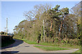
10

Lane to Claverley in Shropshire
Looking east, with High Grosvenor Covert on the left.
Image: © Roger Kidd
Taken: 12 Jan 2022
0.11 miles