IMAGES TAKEN NEAR TO
Hilton, BRIDGNORTH, WV15 5NZ
Introduction
This page details the photographs taken nearby to WV15 5NZ by members of the Geograph project.
The Geograph project started in 2005 with the aim of publishing, organising and preserving representative images for every square kilometre of Great Britain, Ireland and the Isle of Man.

There are currently over 7.5m images from over14,400 individuals and you can help contribute to the project by visiting https://www.geograph.org.uk
Image Map
Images are licensed for reuse under creativecommons.org/licenses/by-sa/2.0
Notes
- Clicking on the map will re-center to the selected point.
- The higher the marker number, the further away the image location is from the centre of the postcode.
Image Listing (21 Images Found)
Images are licensed for reuse under creativecommons.org/licenses/by-sa/2.0
Image
Details
Distance
1
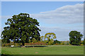
Pasture south of Chesterton, Shropshire
Farm land here now seems to be associated with Greenfields Farm rather than Gainsborough Farm shown on maps.
Image: © Roger D Kidd
Taken: 20 Oct 2015
0.13 miles
2
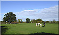
Grazing horses south of Chesterton, Shropshire
Farm land here now seems to be attached to Greenfields Farm rather than Gainsborough Farm shown on maps.
Image: © Roger D Kidd
Taken: 20 Oct 2015
0.14 miles
3
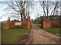
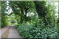
Stratford House Gates
The view from Stratford Lane near Hilton.
Image: © Gordon Griffiths
Taken: 24 Feb 2017
0.18 miles
6
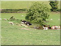
Midday Shade
Sheep shelter from the sun alongside Stratford Brook near Chesterton, Shropshire.
Image: © Gordon Griffiths
Taken: 21 May 2010
0.21 miles
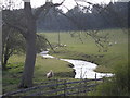
7
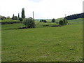
Stratford Brook
The Brook runs through a field near Chesterton, Shropshire.
Image: © Gordon Griffiths
Taken: 21 May 2010
0.21 miles
10

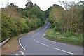
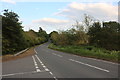
Hump by Stratford Lane, Hilton
These are common in the area and seem related to the outcrops of sandstone which make up much of the local geology.
Image: © David Howard
Taken: 30 May 2020
0.21 miles