IMAGES TAKEN NEAR TO
Bog Cottages, BRIDGNORTH, WV15 5LU
Introduction
This page details the photographs taken nearby to Bog Cottages, WV15 5LU by members of the Geograph project.
The Geograph project started in 2005 with the aim of publishing, organising and preserving representative images for every square kilometre of Great Britain, Ireland and the Isle of Man.

There are currently over 7.5m images from over14,400 individuals and you can help contribute to the project by visiting https://www.geograph.org.uk
Image Map
Images are licensed for reuse under creativecommons.org/licenses/by-sa/2.0
Notes
- Clicking on the map will re-center to the selected point.
- The higher the marker number, the further away the image location is from the centre of the postcode.
Image Listing (11 Images Found)
Images are licensed for reuse under creativecommons.org/licenses/by-sa/2.0
Image
Details
Distance
1
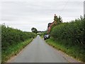
Bog Cottages
The view near Cranmere Farm, Shropshire.
Image: © Gordon Griffiths
Taken: 4 Aug 2020
0.01 miles
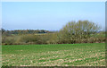
2
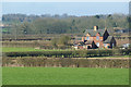
Shropshire farmland north of Worfield
This telephoto assisted image from near Cranmere Farm shows The Bog Cottages from about five hundred metres distance. The Bog is off to the right.
Image: © Roger D Kidd
Taken: 11 Mar 2014
0.01 miles

5
Shropshire farmland north of Worfield
This image looking towards land north of Hartlebury, from near Cranmere Farm, shows The Bog Cottages from about five hundred metres distance. The Bog is off to the right.
Image: © Roger D Kidd
Taken: 11 Mar 2014
0.15 miles
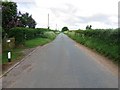
6
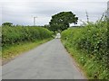
Lane View
The view along the lane by The Bog, Shropshire
Image: © Gordon Griffiths
Taken: 4 Aug 2020
0.22 miles
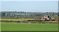
7
Farmland by The Bog, north of Worfield, Shropshire
The bog is beyond the next field behind the hedge. This is a peat based depression up to about three metres in depth, about 380 metres by 190 metres.
Image: © Roger D Kidd
Taken: 11 Mar 2014
0.23 miles
8
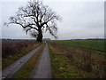
Track to Common Farm
The access track down to Common Farm, with a newly-planted hedge on the right.
Image: © Richard Law
Taken: 19 Feb 2011
0.24 miles
9
The Bog
The view from the lane at Cranmere in Shropshire.
Image: © Gordon Griffiths
Taken: 16 Apr 2018
0.25 miles
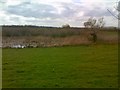
10
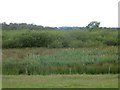
The Bog
A big area of marshland marked as a circular pond on maps.
Image: © Richard Webb
Taken: 30 Jun 2014
0.25 miles