IMAGES TAKEN NEAR TO
Tettenhall Road, WOLVERHAMPTON, WV1 4SB
Introduction
This page details the photographs taken nearby to Tettenhall Road, WV1 4SB by members of the Geograph project.
The Geograph project started in 2005 with the aim of publishing, organising and preserving representative images for every square kilometre of Great Britain, Ireland and the Isle of Man.

There are currently over 7.5m images from over14,400 individuals and you can help contribute to the project by visiting https://www.geograph.org.uk
Image Map
Images are licensed for reuse under creativecommons.org/licenses/by-sa/2.0
Notes
- Clicking on the map will re-center to the selected point.
- The higher the marker number, the further away the image location is from the centre of the postcode.
Image Listing (246 Images Found)
Images are licensed for reuse under creativecommons.org/licenses/by-sa/2.0
Image
Details
Distance
1
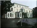
Salisbury House - 2 & 2a Tettenhall Road
Grade 2 listed gentleman's residence dating from the mid 19th century. It was home to local ironmaster George Benjamin Thorneycroft who served as the first Mayor of Wolverhampton in 1848. It now houses offices for a firm of architects.
Image: © John M
Taken: 2 Oct 2010
0.01 miles
2
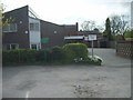
Wolverhampton Quaker's Meeting House
The Friends House in Summerfield Road.
Image: © Gordon Griffiths
Taken: 3 May 2008
0.02 miles
3
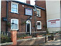
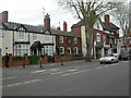
Combermere Arms
A Pub in Tettenhall Road.
Image: © Gordon Griffiths
Taken: 21 Oct 2007
0.02 miles
4
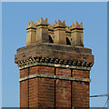
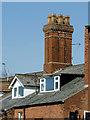
Chimney stack in Tettenhall Road, Wolverhampton
Seen from the rear of the late Victorian building, No 9 Tettenhall Road, now let as flats. One of these chimney pots is beginning to appear precarious, so we will see what maintenance is done in future years.
Image: © Roger D Kidd
Taken: 9 Mar 2014
0.04 miles
5
Dormers and chimney stack near Chapel Ash
Seen from Compton Road, this detail is of an upgraded late Victorian house in Tettenhall Road, now divided into flats.
Image: © Roger D Kidd
Taken: 9 Mar 2014
0.04 miles
6
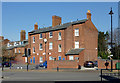
Large house near Chapel Ash. Wolverhampton
Compton Road.
This is the rear of housing in Tettenhall Road (No 5 and No 7), seen from the junction of Merridale Road with Compton Road. They appear to be divided into flats now.
Image: © Roger D Kidd
Taken: 9 Mar 2014
0.04 miles
7
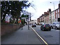
Tettenhall Road View
The view up the A41 Tettenhall Road towards Wolverhampton City Centre.
Image: © Gordon Griffiths
Taken: 2 Feb 2014
0.05 miles
8

Music School on Bath Road
Dr Ernest Darby and Madame Parkes Darby ran a music school from this Victorian house near the West Park from the early 1930s to the 1970s. Latterly it has been used for medical consulting rooms and dental surgeries.
Image: © John M
Taken: 2 Jun 2007
0.05 miles
9
Wolverhampton, Combermere Arms
Pub at the West end of Chapel Ash (A41); internally, central corridor with counter, to left, bar, to right, two further rooms, courtyard. Outdoor gents' loo, built around lime tree. Cask ales on offer at my visit: Banks's Bitter, Original; Butcombe Brunel; Wychwood Hobgoblin; Deuchar's IPA. Good Beer Guide 2009-listed.
Image: © Mike Faherty
Taken: 26 Apr 2009
0.05 miles
10
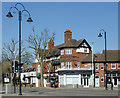
Shops at Chapel Ash, Wolverhampton
This is at the five-way junction where Chapel Ash becomes Tettenhall Road, Bath Road joins where Bella's shop is, and Merridale Road comes in (off to the left). Clifton Street is behind the camera.
Image: © Roger D Kidd
Taken: 9 Mar 2014
0.06 miles