IMAGES TAKEN NEAR TO
Birch Street, WV1 4BF
Introduction
This page details the photographs taken nearby to Birch Street, WV1 4BF by members of the Geograph project.
The Geograph project started in 2005 with the aim of publishing, organising and preserving representative images for every square kilometre of Great Britain, Ireland and the Isle of Man.

There are currently over 7.5m images from over14,400 individuals and you can help contribute to the project by visiting https://www.geograph.org.uk
Image Map
Images are licensed for reuse under creativecommons.org/licenses/by-sa/2.0
Notes
- Clicking on the map will re-center to the selected point.
- The higher the marker number, the further away the image location is from the centre of the postcode.
Image Listing (856 Images Found)
Images are licensed for reuse under creativecommons.org/licenses/by-sa/2.0
Image
Details
Distance
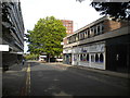
1
Crown House View
The view of the Government Offices in Birch Street.
Image: © Gordon Griffiths
Taken: 31 Jan 2013
0.00 miles
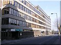
2
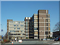
Office block in Wolverhampton
Crown House. This block of government offices is viewed from about eighty metres looking across the Chapel Ash Island roundabout. Darlington Street is off to the right.
Image: © Roger D Kidd
Taken: 9 Mar 2014
0.01 miles
3
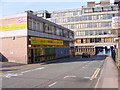
Clarence Street Scene
Ladies only in this Wolverhampton Fitness Centre.
Image: © Gordon Griffiths
Taken: 10 Apr 2010
0.02 miles
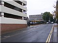
4
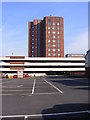
Birch Street Car Park View
The view from Clarence Street.
Image: © Gordon Griffiths
Taken: 10 Apr 2010
0.02 miles
6
Crown House
The offices in Birch Street.
Image: © Gordon Griffiths
Taken: 10 Apr 2010
0.03 miles
7
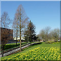
Public park in Wolverhampton Ring Road
From here at the Chapel Ash roundabout, clockwise to the crossroads at Waterloo Road, the two carriageways of the ring road are separated by a wide and attractively landscaped strip of public parkland. Mature trees and bushes are augmented by well attended grassy areas with cast iron framed seats. The slope shown here leads down to the centre of the roundabout, also similarly landscaped. The tree remains shown in 2009 http://www.geograph.org.uk/photo/1562031 has gone, but these daffodils make a cheerful replacement in the spring. The shrubs have been severely cut back, though!
Image: © Roger D Kidd
Taken: 9 Mar 2014
0.03 miles
8
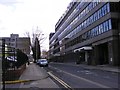
Birch Street, Wolverhampton
Seen from Darlington Street.
Image: © Richard Vince
Taken: 24 Sep 2017
0.03 miles
9
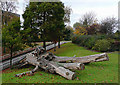
Linear Park inside Wolverhampton Ring Road
From here at the Chapel Ash roundabout, clockwise to the crossroads at Waterloo Road, the two carriageways of the ring road are separated by a wide and attractively landscaped strip of public parkland. Mature trees and bushes are augmented by well attended grassy areas with cast iron framed seats. The slope shown here leads down to the centre of the roundabout, also similarly landscaped, but marred in places by the usual moronic graffiti on the outer walls. I hope this tree remnant has been deliberately left as a semi-permanent feature.
Image: © Roger D Kidd
Taken: 30 Oct 2009
0.03 miles
10
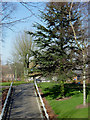
Public park within Wolverhampton Ring Road
From here at the Chapel Ash roundabout, clockwise to the crossroads at Waterloo Road, the two carriageways of the ring road are separated by a wide and attractively landscaped strip of public parkland. Mature trees and bushes are augmented by well attended grassy areas with cast iron framed seats. I notice that considerable re-landscaping has been done since the current satellite image was recorded. Many shrubs have gone. This pathway leads down to the landscaped central area of Chapel Ash Island.
Image: © Roger D Kidd
Taken: 9 Mar 2014
0.03 miles