IMAGES TAKEN NEAR TO
Banks Street, WILLENHALL, WV13 1SP
Introduction
This page details the photographs taken nearby to Banks Street, WV13 1SP by members of the Geograph project.
The Geograph project started in 2005 with the aim of publishing, organising and preserving representative images for every square kilometre of Great Britain, Ireland and the Isle of Man.

There are currently over 7.5m images from over14,400 individuals and you can help contribute to the project by visiting https://www.geograph.org.uk
Image Map
Images are licensed for reuse under creativecommons.org/licenses/by-sa/2.0
Notes
- Clicking on the map will re-center to the selected point.
- The higher the marker number, the further away the image location is from the centre of the postcode.
Image Listing (46 Images Found)
Images are licensed for reuse under creativecommons.org/licenses/by-sa/2.0
Image
Details
Distance
1
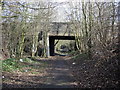
Site of Willenhall Stafford Street Station 2010
In this view we are roughly in the middle of the tracks, Walsall Platform to the left Wolverhampton Platform and station buildings to the right. The earth bank on the right is infill from the building of a new housing estate on the site of the goods yard which extended behind the platform and included a goods shed, stable and overhead crane. The signal box would have been behind the photographer on the right, somewhere under the earthwork. A loop passed to the rear of the Walsall platform and exited via the smaller arch of the bridge.
Image: © Tim Marshall
Taken: 2 Mar 2010
0.07 miles
2
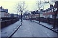
Dartmouth Avenue, Willenhall.
Dartmouth Avenue, Willenhall, looking towards The Central Schools, March 1978.
Image: © Tim Marshall
Taken: Unknown
0.09 miles
3
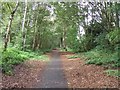
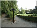
Cycleway on disused railway
This cycleway follows part of the disused railway on the edge of the Memorial Park in Willenhall. The line was opened in 1872 between Wolverhampton and Walsall via Wednesfield and Willenhall. It was closed to passenger traffic in 1931. Closure to goods traffic is believed to be in the early 1960s though a source suggests the slightly earlier date of 1958.
Image: © John M
Taken: 30 Sep 2006
0.09 miles
4
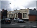
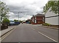
Lockmaking in Willenhall
This is one of the small number of lockmaking firms manufacturing in Willenhall at their 'Imperial Works' on Wednesfield Road.
Image: © John M
Taken: 30 Sep 2006
0.11 miles
5
Memorial Close, Willenhall from Field Street.
This estate was built on the site of the goods yard of the former Willenhall Stafford Street Station which was closed and demolished in 1965.
Image: © Tim Marshall
Taken: 2 Mar 2010
0.11 miles
6
Willenhall Memorial Park
The park was opened in 1922 in honour of those killed in the Great War.
Image: © John M
Taken: 30 Sep 2006
0.12 miles
7
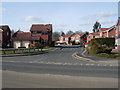
Temple Bar
The view of the crossroads with Leveson Street in Willenhall.
Image: © Gordon Griffiths
Taken: 9 May 2021
0.13 miles
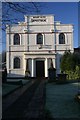
9
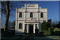
Mount Olive Apostolic Church
It was a sharp frost morning when I was passing this church, it stands in what was once a heavily industrialised area, I had to stop and photograph it.
Image: © Derek Bennett
Taken: 3 Jan 2009
0.14 miles
10
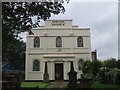
Mount Olive Apostolic Church in Little London
This church on the outskirts of Willenhall was founded in 1792.
Image: © John M
Taken: 30 Sep 2006
0.14 miles