IMAGES TAKEN NEAR TO
Wootton Avenue, WOLVERHAMPTON, WV11 3AA
Introduction
This page details the photographs taken nearby to Wootton Avenue, WV11 3AA by members of the Geograph project.
The Geograph project started in 2005 with the aim of publishing, organising and preserving representative images for every square kilometre of Great Britain, Ireland and the Isle of Man.

There are currently over 7.5m images from over14,400 individuals and you can help contribute to the project by visiting https://www.geograph.org.uk
Image Map
Images are licensed for reuse under creativecommons.org/licenses/by-sa/2.0
Notes
- Clicking on the map will re-center to the selected point.
- The higher the marker number, the further away the image location is from the centre of the postcode.
Image Listing (26 Images Found)
Images are licensed for reuse under creativecommons.org/licenses/by-sa/2.0
Image
Details
Distance
1
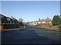
Ridge Lane - Wood End
The Monarch's Way passes along a residential street on the fringe of the West Midlands conurbation. A brief stroll lets the traveller join the towpath of the Curly Wyrley canal for the journey to Bentley Hall.
Image: © John M
Taken: 6 Dec 2008
0.09 miles
2
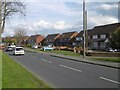
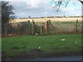
Linthouse Lane
Houses on the edge of a vast urban area. They still overlook fields.
Image: © Richard Webb
Taken: 13 Apr 2016
0.12 miles
3
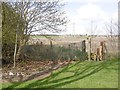
Path off Linthouse Lane
Still the edge of the urban area and consequently the Wolverhampton council area. If its growing stuff it is probably in Staffordshire Council's area.
Image: © Richard Webb
Taken: 13 Apr 2016
0.14 miles
4
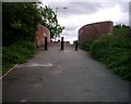
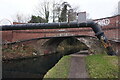
Canal Bridge at the bottom of Hyde Road
This bridge was locally known as the "Dump Bridge" in the 1970s , as there was lots of rubbish was often dumped here. This is actually Moathouse Lane Bridge. There was once a Council Depot on the other side of the bridge and I vaguely remember seeing skips here.
Image: © A Holmes
Taken: 1 Jun 2002
0.16 miles
5
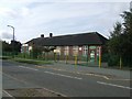
Wood End Primary School
Tessa Sanderson, Olympic Javelin Gold medallist, and I attended the school in the 1960s. I believe our memories of the school were somewhat different.
Image: © John M
Taken: 5 Sep 2009
0.17 miles
6
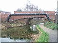
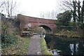
Moathouse Lane Bridge
This bridge carries a footpath and cycleway over the Wyrley and Essington Canal. The canal by following the contours has no locks on this section but takes a very meandering route hence its nickname 'Curly Wyrley'.
This bridge has been partially rebuilt and extended as can be seen from the change in brick colour.
Image: © John M
Taken: 26 Dec 2006
0.17 miles
7
Monarch's Way Wednesfield
The Way at Linthouse Lane.
Image: © Gordon Griffiths
Taken: 10 Jan 2008
0.17 miles
8
Wyrley & Essington Canal at Moat House Bridge
Image: © Ian S
Taken: 16 Dec 2021
0.17 miles
9
Wyrley & Essington Canal at Moat House Bridge
Image: © Ian S
Taken: 16 Dec 2021
0.17 miles
10
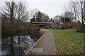
Wyrley & Essington Canal at Moat House Bridge
Image: © Ian S
Taken: 16 Dec 2021
0.17 miles