IMAGES TAKEN NEAR TO
High Hill, WOLVERHAMPTON, WV11 2DW
Introduction
This page details the photographs taken nearby to High Hill, WV11 2DW by members of the Geograph project.
The Geograph project started in 2005 with the aim of publishing, organising and preserving representative images for every square kilometre of Great Britain, Ireland and the Isle of Man.

There are currently over 7.5m images from over14,400 individuals and you can help contribute to the project by visiting https://www.geograph.org.uk
Image Map
Images are licensed for reuse under creativecommons.org/licenses/by-sa/2.0
Notes
- Clicking on the map will re-center to the selected point.
- The higher the marker number, the further away the image location is from the centre of the postcode.
Image Listing (14 Images Found)
Images are licensed for reuse under creativecommons.org/licenses/by-sa/2.0
Image
Details
Distance
1
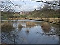
Fishing pool in the Forest of Mercia
On the fringe of the Forest of Mercia this land was formerly a colliery tip.
Image: © John M
Taken: 5 Apr 2009
0.10 miles
2
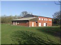
Essington Rugby Club
Champions in 2009 of Midlands 6 West (North)
Image: © John M
Taken: 29 Mar 2009
0.14 miles
3
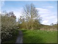
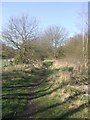
Ashmore Park to Essington path
Crossing a park/informal open space which shows signs of mining.
Image: © Richard Webb
Taken: 13 Apr 2016
0.14 miles
4
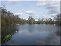
Forest of Mercia - Brownshore Lane
This land on the former Vernon Estate was given by the family to the people of Essington in 2000 in recognition of their connection with the village since 1547. The land was a previously used as a spoil tip for the nearby Essington Wood Colliery.
Image: © John M
Taken: 5 Apr 2009
0.16 miles
5
Kitchen Lane, Ashmore Park
Kitchen Lane predates Ashmore Park and once passed a colliery here. A path leaves the road here for Essington.
Image: © Richard Webb
Taken: 13 Apr 2016
0.18 miles
6
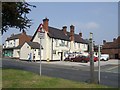
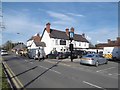
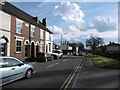
The Minerva
Public House in the former mining village of Essington.
Image: © John M
Taken: 10 Jun 2007
0.19 miles
8
Former colliery railway
The footpath runs along the trackbed of the mineral railway which served Hilton Main Colliery. In the early 1960s as a child I was often taken by my mother to see a small diesel engine pulling a trainload of coal. This would happen every day at around 4pm.
The line was an extension of the Wolverhampton and Cannock Chase Colliery's Line to the Essington and Holly Bank pits. There was a connection to the Walsall to Cannock Line at Norton. A spur ran to the Rosemary Brick and Tile Works.
Image: © John M
Taken: 29 Mar 2009
0.20 miles
10
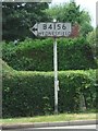
Old 'B4156 WEDNESFIELD' road sign
I have passed this one for many years without really noticing it.
Image: © John M
Taken: 27 Jul 2013
0.20 miles