IMAGES TAKEN NEAR TO
Hough Way, WOLVERHAMPTON, WV11 2BR
Introduction
This page details the photographs taken nearby to Hough Way, WV11 2BR by members of the Geograph project.
The Geograph project started in 2005 with the aim of publishing, organising and preserving representative images for every square kilometre of Great Britain, Ireland and the Isle of Man.

There are currently over 7.5m images from over14,400 individuals and you can help contribute to the project by visiting https://www.geograph.org.uk
Image Map
Images are licensed for reuse under creativecommons.org/licenses/by-sa/2.0
Notes
- Clicking on the map will re-center to the selected point.
- The higher the marker number, the further away the image location is from the centre of the postcode.
Image Listing (17 Images Found)
Images are licensed for reuse under creativecommons.org/licenses/by-sa/2.0
Image
Details
Distance

3
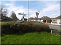
Signpost, Essington
Brown shore Lane/Wolverhampton road junction with a finger post.
Image: © Richard Webb
Taken: 13 Apr 2016
0.11 miles
4
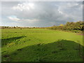
Footpath towards the motorways
Leading across a sunlit field, the footpath out of Essington here follows the hedgeline to a junction at the far end.
Image: © Richard Law
Taken: 6 Oct 2014
0.14 miles
5
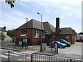
Essington Community Centre
Former village school dating from 1911 is now a community centre and home for a pre-school playgroup. The new school is across the road.
Image: © John M
Taken: 3 Jun 2007
0.17 miles
6
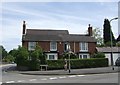
The Old Vicarage
There was originally another church on the other side of Hobnock Road. Possibly there would have been another chimney in the centre of the building
Image: © John M
Taken: 3 Jun 2007
0.19 miles
7
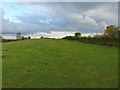
British. And apparently proud of it.
The owner of this field, with its grazing ponies, appears to be a proud Brit - he flies a Union flag from the pole on the hillock just ahead; it's visible from the M6 just off to the left.
Image: © Richard Law
Taken: 6 Oct 2014
0.20 miles
9
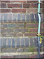
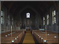
OS benchmark - Essington, St John's church
An OS cutmark at the base of the tower of Image; originally levelled at 183.429m above Ordnance Datum Newlyn.
Image: © Richard Law
Taken: 6 Oct 2014
0.22 miles
10
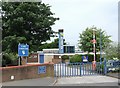
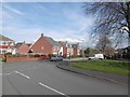
St Johns Primary School
The primary school in the former mining village outgrew the old buildings as new estates were built. A further building boom has recently taken place with commuter homes built on brownfield sites.
Image: © John M
Taken: 3 Jun 2007
0.23 miles