IMAGES TAKEN NEAR TO
New Landywood Lane, WOLVERHAMPTON, WV11 2AW
Introduction
This page details the photographs taken nearby to New Landywood Lane, WV11 2AW by members of the Geograph project.
The Geograph project started in 2005 with the aim of publishing, organising and preserving representative images for every square kilometre of Great Britain, Ireland and the Isle of Man.

There are currently over 7.5m images from over14,400 individuals and you can help contribute to the project by visiting https://www.geograph.org.uk
Image Map
Images are licensed for reuse under creativecommons.org/licenses/by-sa/2.0
Notes
- Clicking on the map will re-center to the selected point.
- The higher the marker number, the further away the image location is from the centre of the postcode.
Image Listing (14 Images Found)
Images are licensed for reuse under creativecommons.org/licenses/by-sa/2.0
Image
Details
Distance
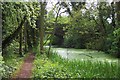
2
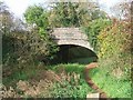
Bakers Bridge
Bridge built for the local farmer over the Wyrley Branch Canal. The canal was closed in the 1950s and the towpath now forms part of a linear path.
Image: © John M
Taken: 12 Nov 2006
0.02 miles
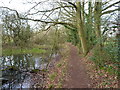
4
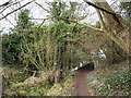
Baker Bridge, Upper Landywood
An agricultural accommodation bridge, built at the time the canal was constructed in the 1790s, and now much more overgrown than it was even 12 years ago Image
Image: © Richard Law
Taken: 14 Jan 2019
0.07 miles
5
Abandoned stretch of Wyrley & Essington Canal, 1986
An overgrown part of the canal heading towards Baker Bridge in the Upper Landywood area, south of Great Wyrley. The location from which the image was recorded appears now, (2021), to be under or at least close to an industrial site concerning gas.
Image: © Trevor Littlewood
Taken: 14 Jun 1986
0.07 miles
6
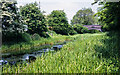
Wyrley and Essington Canal
Looking South
Image: © Geoff Pick
Taken: 25 May 2006
0.08 miles
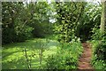
7
Wyrley Bank branch of the Wyrley & Essington Canals
Originally part of the Birmingham Canal Navigations system, the Wyrley Bank branch opened in 1798 and ran from Sneyd to Wyrley Bank; it was later extended to Great Wyrley in the 1850s in order to carry coal from the mines in that area. The whole thing is looking somewhat neglected these days, with low water levels and an air of unkemptness, which is a pity as it's a local nature reserve.
Image: © Richard Law
Taken: 14 Jan 2019
0.12 miles
8
Wyrley and Essington Canal
Wyrley Arm - disused
Image: © Geoff Pick
Taken: 25 May 2006
0.14 miles
10
Near Upper Landywood
From the Canal Bridge looking NE
Image: © Geoff Pick
Taken: 25 May 2006
0.20 miles