IMAGES TAKEN NEAR TO
Wordsworth Road, WOLVERHAMPTON, WV10 8RT
Introduction
This page details the photographs taken nearby to Wordsworth Road, WV10 8RT by members of the Geograph project.
The Geograph project started in 2005 with the aim of publishing, organising and preserving representative images for every square kilometre of Great Britain, Ireland and the Isle of Man.

There are currently over 7.5m images from over14,400 individuals and you can help contribute to the project by visiting https://www.geograph.org.uk
Image Map
Images are licensed for reuse under creativecommons.org/licenses/by-sa/2.0
Notes
- Clicking on the map will re-center to the selected point.
- The higher the marker number, the further away the image location is from the centre of the postcode.
Image Listing (65 Images Found)
Images are licensed for reuse under creativecommons.org/licenses/by-sa/2.0
Image
Details
Distance
1
Polling Station - Wolverhampton North East
Polling station for the 2010 General Election at the Scotlands Adventure Playground. The polling station serves a 1930s Council Estate with some houses bought under 'Right to Buy' schemes. The demographic is working class with social deprivation and high unemployment.
Image: © John M
Taken: 6 May 2010
0.05 miles
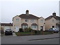
2
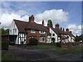
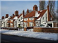
Council Housing - Pre-war housing in Primrose Lane
These council built properties from late 1930s retain many of their original features. They were the larger design with parlours for rent at 15/1 per week. Larger houses on the fringes of the estates were often sold to private owners.
Image: © John M
Taken: 7 May 2007
0.06 miles
3
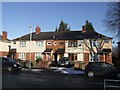
Council Housing - Chesterton Road
The houses on the Scotlands Estate were completed in 1937. The roads are named after poets and writers, Pope, Dickens, Keats etc.
Image: © John M
Taken: 20 Dec 2009
0.08 miles
4
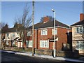
Council Housing - Chesterton Road
Semi-detached house on the 1937 Scotlands Estate.
Image: © John M
Taken: 20 Dec 2009
0.10 miles
6
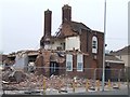
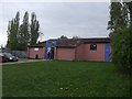
Last days of the New Highcroft
The locally listed public house on the 1930s council estate is being demolished to make way for a care home. Local residents are pleased to see it go.Image]
Image: © John M
Taken: 27 Mar 2011
0.11 miles
7
Council Housing - Old Fallings Lane
Late 1920s housing on the edge of the Bushbury Estate.
Image: © John M
Taken: 27 Mar 2011
0.11 miles
8
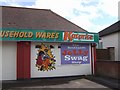
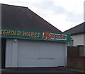
Re-branded outlet at 'The Scotlands'
Image: © John M
Taken: 27 Mar 2011
0.11 miles
9
Council Housing - Primrose Lane
Unusual houses built on the edges of the Bushbury Estate in the late 1930s. The larger houses may have been council built for private sale. These examples have many of their original features.
Image: © John M
Taken: 12 Dec 2017
0.12 miles
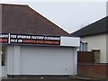
10
Invitation withdrawn at The Scotlands?
The somewhat tasteless sign shown on Image has been removed.
Image: © John M
Taken: 8 Nov 2009
0.12 miles