IMAGES TAKEN NEAR TO
Primrose Lane, WOLVERHAMPTON, WV10 8RS
Introduction
This page details the photographs taken nearby to Primrose Lane, WV10 8RS by members of the Geograph project.
The Geograph project started in 2005 with the aim of publishing, organising and preserving representative images for every square kilometre of Great Britain, Ireland and the Isle of Man.

There are currently over 7.5m images from over14,400 individuals and you can help contribute to the project by visiting https://www.geograph.org.uk
Image Map
Images are licensed for reuse under creativecommons.org/licenses/by-sa/2.0
Notes
- Clicking on the map will re-center to the selected point.
- The higher the marker number, the further away the image location is from the centre of the postcode.
Image Listing (69 Images Found)
Images are licensed for reuse under creativecommons.org/licenses/by-sa/2.0
Image
Details
Distance
1
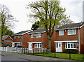
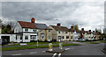
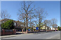
Housing in Old Fallings Lane, Wolverhampton
Recently built homes near the roundabout junction with Primrose Lane. Most of the housing nearby is from the 1920s-1930s era.
Image: © Roger D Kidd
Taken: 30 Apr 2015
0.05 miles
2
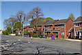
Housing in Old Fallings Lane near Low Hill, Wolverhampton
Looking north towards the roundabout by Primrose Lane. The hideous purple "garden wast" bins await emptying. When the council decided to charge £35 per year for collecting garden waste, they decided to abandon the previous sensible green bins, and instead of getting a "discreet" colour chose this, causing eyesores all over the city!
Image: © Roger Kidd
Taken: 22 Apr 2021
0.05 miles
3
Housing in Old Fallings Lane, Wolverhampton
Recently built homes near the roundabout junction with Primrose Lane.
Image: © Roger D Kidd
Taken: 30 Apr 2015
0.05 miles
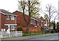
4
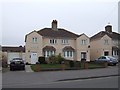
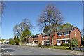
Council Housing - Primrose Lane
Unusual houses built on the edges of the Bushbury Estate in the late 1930s. The larger houses may have been council built for private sale. These examples have many of their original features.
Image: © John M
Taken: 12 Dec 2017
0.06 miles
5
Primrose Lane near Old Fallings, Wolverhampton
The western end of Primrose Lane by the roundabout and junction with Old Fallings Lane.
Image: © Roger D Kidd
Taken: 30 Apr 2015
0.06 miles
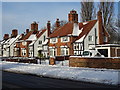
6
Council Housing - Old Fallings Lane
Late 1920s housing on the edge of the Bushbury Estate.
Image: © John M
Taken: 27 Mar 2011
0.06 miles
7
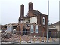
Last days of the New Highcroft
The locally listed public house on the 1930s council estate is being demolished to make way for a care home. Local residents are pleased to see it go.Image]
Image: © John M
Taken: 27 Mar 2011
0.06 miles
8
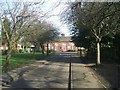
Old Fallings Primary School
Situated down a driveway on Old Fallings Lane opposite St Chad's Sports College.
Image: © John M
Taken: 4 Feb 2007
0.06 miles
9
Old Fallings Lane near Low Hill, Wolverhampton
Looking north-north-west by the Primrose Hill Care Home.
Image: © Roger Kidd
Taken: 22 Apr 2021
0.06 miles
10
Housing in Old Fallings Lane near Low Hill, Wolverhampton
Looking north towards the roundabout by Primrose Lane.
Image: © Roger Kidd
Taken: 22 Apr 2021
0.06 miles