IMAGES TAKEN NEAR TO
Old Fallings Lane, WOLVERHAMPTON, WV10 8BY
Introduction
This page details the photographs taken nearby to Old Fallings Lane, WV10 8BY by members of the Geograph project.
The Geograph project started in 2005 with the aim of publishing, organising and preserving representative images for every square kilometre of Great Britain, Ireland and the Isle of Man.

There are currently over 7.5m images from over14,400 individuals and you can help contribute to the project by visiting https://www.geograph.org.uk
Image Map
Images are licensed for reuse under creativecommons.org/licenses/by-sa/2.0
Notes
- Clicking on the map will re-center to the selected point.
- The higher the marker number, the further away the image location is from the centre of the postcode.
Image Listing (56 Images Found)
Images are licensed for reuse under creativecommons.org/licenses/by-sa/2.0
Image
Details
Distance
1
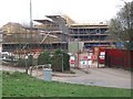
Moreton School - Bushbury Hill
One of two new junior schools to be built this year. The all timber design is similar to the award winning scheme in Blakenhall. The ridge of Bushbury Hill is a finger of open fields with views out into South Staffordshire and Shropshire. The original Bushbury Hill School was built to serve the council estates of Low Hill of the late 1920s and early 1930s. I am told that the school was opened around 1934 by minor royalty.
Image: © John M
Taken: 27 Mar 2011
0.03 miles
2
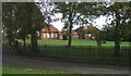
Bushbury Junior School
This school is near the top of Bushbury Hill. The trackway on the left leads along the ridge of the hill to Northycote Farm where it joins the Monarch's Way.
Image: © John M
Taken: 5 Nov 2006
0.04 miles
3
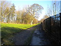
Bridleway over Bushbury Hill
Passing Bushbury Hill Junior and Infants' Schools just north of Old Fallings Lane.
Image: © Richard Vince
Taken: 28 Dec 2016
0.04 miles
4
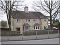
Council Housing - Old Fallings Lane
Concrete houses dating from late 1920s.
Image: © John M
Taken: 27 Mar 2011
0.08 miles
5
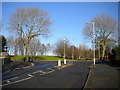
Top of Leacroft Avenue, Bushbury Hill estate
For many years, this junction, where Leacroft Avenue (foreground) meets Old Fallings Lane, was used by buses to turn round. The Bushbury Hill trolleybus service (latterly numbered 3) approached via Leacroft Avenue, though by the time buses stopped turning here, the equivalent service (by then numbered 598) had been rerouted to approach via Old Fallings Lane. The current route linking Bushbury Hill with Wolverhampton city centre, service 2, operates a one way loop around the estate and thus no longer needs to turn here.
Image: © Richard Vince
Taken: 28 Dec 2016
0.09 miles
6
Bushbury Hill
From this direction the telecom mast Image and reservoirs almost merge into the belt of trees. From most other directions these are very noticeable.
Image: © John M
Taken: 23 Dec 2007
0.09 miles
7
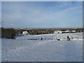
Slopes of Bushbury Hill
The favourite sledging slopes of my childhood above Bushbury Hall are fenced off.
Image: © John M
Taken: 12 Dec 2017
0.11 miles
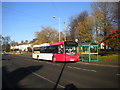
8
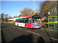
Bus on Old Fallings Lane, Bushbury Hill estate (2)
National Express West Midlands 2010, a Volvo B7RLE/Wrightbus Eclipse Urban 2, waits at the nominal terminus of route 2 (for which it carries route branding) before heading back to Warstones estate via Wolverhampton city centre.
Image: © Richard Vince
Taken: 28 Dec 2016
0.13 miles
9
Bus on Old Fallings Lane, Bushbury Hill estate (1)
National Express West Midlands 2026, a Volvo B7RLE/Wrightbus Eclipse Urban 2, waits at the nominal terminus of route 2 before heading back to Warstones estate via Wolverhampton city centre.
Image: © Richard Vince
Taken: 28 Dec 2016
0.13 miles
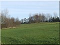
10
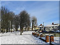
Council Housing - Old Fallings Lane
Open space with trees.
Image: © John M
Taken: 12 Dec 2017
0.13 miles