IMAGES TAKEN NEAR TO
Underhill Lane, WOLVERHAMPTON, WV10 7JF
Introduction
This page details the photographs taken nearby to Underhill Lane, WV10 7JF by members of the Geograph project.
The Geograph project started in 2005 with the aim of publishing, organising and preserving representative images for every square kilometre of Great Britain, Ireland and the Isle of Man.

There are currently over 7.5m images from over14,400 individuals and you can help contribute to the project by visiting https://www.geograph.org.uk
Image Map
Images are licensed for reuse under creativecommons.org/licenses/by-sa/2.0
Notes
- Clicking on the map will re-center to the selected point.
- The higher the marker number, the further away the image location is from the centre of the postcode.
Image Listing (83 Images Found)
Images are licensed for reuse under creativecommons.org/licenses/by-sa/2.0
Image
Details
Distance
1
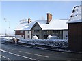
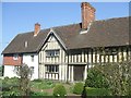
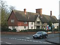
Northycote Farm
Grade II Listed Northycote Farm is now run by Wolverhampton Council as part of a Country Park. The black paintwork was removed in the 1980s to reveal the timber beams. The farm dates from around 1600 with 18th and 19th century additions.
Image: © John M
Taken: 6 Apr 2008
0.01 miles
2
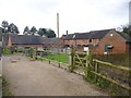
Northicote Farm
Farm buildings, café and wildlife centre at Northicote Farm Country Park: http://www.wolverhampton.gov.uk/article/1877/Northycote-Farm-and-Country-Park
Image: © Mike Faherty
Taken: 23 Dec 2014
0.01 miles
3
The 'Black and White Farm'
Restored in the 1980s by Wolverhampton Council as part of the Northycote Country Park. Until the road was re-graded this marked the start of a wicked but relatively short climb now reduced to a drag past the Crematorium on Bushbury Hill.
Image: © John M
Taken: 28 Mar 2016
0.01 miles
4
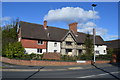
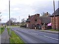
Northicote Farmhouse
C17 farmhouse at the corner of Underhill and Legs Lanes, listed by English Heritage: http://www.imagesofengland.org.uk/Details/Default.aspx?id=378605&mode=adv
Image: © Mike Faherty
Taken: 23 Dec 2014
0.01 miles
5
Northycote Farm
Grade II listed farmhouse and outbuildings now owned by the City Council. The black and white paintwork was stripped off when the building was renovated in the early 1980s.
Image: © John M
Taken: 1 Apr 2012
0.01 miles
6
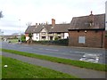
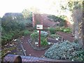
Northycote Farm
The view of Northycote Farm Country Park, Wolverhampton.
Image: © Gordon Griffiths
Taken: 1 Apr 2017
0.01 miles
7
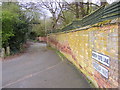
Northcote Lane Wall
The view alongside Northycote Farm Country Park, Wolverhampton.
Image: © Gordon Griffiths
Taken: 1 Apr 2017
0.02 miles
8

Northycote Lane
New roads associated with 1980s housing expansion on the edge of Wolverhampton have bypassed this former narrow country lane. It now serves as a bridleway next to the Country Park.
Image: © John M
Taken: 19 Nov 2006
0.02 miles
9
Former Chapel
This was the private chapel for the families from Moseley Court and Moseley Old Hall. The families were Catholic like other notable families such as the Giffards of Chillington and therefore needed to worship in private. The chapel fell into decay when Moseley Court was demolished.
Image: © John M
Taken: 19 Nov 2006
0.02 miles
10
The 'Black and White Farm'
Grade II Listed Northycote Farm is now run by Wolverhampton Council as part of a Country Park. The black paintwork was removed in the 1980s to reveal the timber beams. The farm dates from around 1600 with 18th and 19th century additions.
Image: © John M
Taken: 25 Nov 2006
0.02 miles