IMAGES TAKEN NEAR TO
Queens Road, WOLVERHAMPTON, WV10 7DS
Introduction
This page details the photographs taken nearby to Queens Road, WV10 7DS by members of the Geograph project.
The Geograph project started in 2005 with the aim of publishing, organising and preserving representative images for every square kilometre of Great Britain, Ireland and the Isle of Man.

There are currently over 7.5m images from over14,400 individuals and you can help contribute to the project by visiting https://www.geograph.org.uk
Image Map
Images are licensed for reuse under creativecommons.org/licenses/by-sa/2.0
Notes
- Clicking on the map will re-center to the selected point.
- The higher the marker number, the further away the image location is from the centre of the postcode.
Image Listing (50 Images Found)
Images are licensed for reuse under creativecommons.org/licenses/by-sa/2.0
Image
Details
Distance
1
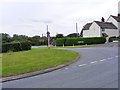
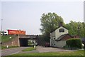
Queens Road
The road junction near the Dog and Partridge pub and the M6 motorway with the Straight Mile near Four Crosses, Staffordshire.
Image: © Gordon Griffiths
Taken: 31 Aug 2012
0.04 miles
2
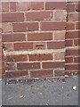
OS benchmark - Calf Heath, The Dog & Partridge pub
An OS cutmark on the external wall of the Dog & Partridge pub; originally levelled at 106.768m above Ordnance Datum Newlyn.
Image: © Richard Law
Taken: 21 Jul 2016
0.07 miles
4
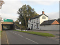
Motorway Pub
The Dog and Partridge pub stands alongside the M6 motorway on the Straight Mile near Four Crosses, Staffordshire.
Image: © Gordon Griffiths
Taken: 31 Aug 2012
0.07 miles
6
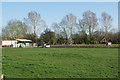
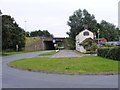
Facilities for horses at Calf Heath
Much of the local green land is available for horses. Although not visible from here, the disused Hatherton Canal runs in front of the houses.
Image: © Bill Boaden
Taken: 19 Apr 2018
0.12 miles
7
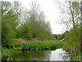
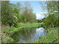
The Hatherton Canal near Calf Heath in Staffordshire
This is the canal above Lock No 2 east of Hatherton Junction.
The Hatherton Canal was opened in 1841, and extended in 1863. It remained in use for carrying coal until 1949 and was formally abandoned in 1955. It is not navigable above this lock but remains as a feeder to the Staffordshire and Worcestershire Canal at Hatherton Junction three hundred metres west-south-west. Restoration is planned, but re-opening is many years away. http://www.lhcrt.org.uk/ http://captainahabswaterytales.blogspot.co.uk/2010/02/hatherton-branch-canal.html
Image: © Roger D Kidd
Taken: 3 May 2012
0.13 miles
8
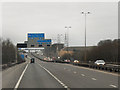
Southbound M6, approaching the M6 Toll Road
Image: © David Dixon
Taken: 1 Apr 2013
0.13 miles
9
The Hatherton Branch Canal at Calf Heath, Staffordshire
This derelict canal is now only used as a feeder into the Staffordshire and Worcestershire Canal. Behind the camera are the two Calf Heath Locks, a basin occupied as part of the Calf Heath Marina, and Phil Jones's boatyard.
Opened in 1841, and extended in 1863, the canal remained in use for carrying coal until 1949. It was formally abandoned in 1955. It is not navigable above this lock. Restoration is planned, but re-opening is many years away. http://www.lhcrt.org.uk/ http://captainahabswaterytales.blogspot.co.uk/2010/02/hatherton-branch-canal.html
Image: © Roger D Kidd
Taken: 11 May 2012
0.13 miles
10
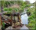
Disused canal near Calf Heath, Staffordshire
Off to the left, Lock No 2 was widened and a shelf built to use as a dry dock by the nearby boatyard. The image shows the top lock gate, in a dilapidated state.
The Hatherton Canal was opened in 1841, and extended in 1863. It remained in use for carrying coal until 1949 and was formally abandoned in 1955. It is not navigable above this lock but remains as a feeder to the Staffordshire and Worcestershire Canal at Hatherton Junction three hundred metres west-south-west. Restoration is planned, but re-opening is many years away. http://www.lhcrt.org.uk/ http://captainahabswaterytales.blogspot.co.uk/2010/02/hatherton-branch-canal.html
Image]
Image: © Roger D Kidd
Taken: 3 May 2012
0.13 miles