IMAGES TAKEN NEAR TO
Oak Lane, WOLVERHAMPTON, WV10 7DR
Introduction
This page details the photographs taken nearby to Oak Lane, WV10 7DR by members of the Geograph project.
The Geograph project started in 2005 with the aim of publishing, organising and preserving representative images for every square kilometre of Great Britain, Ireland and the Isle of Man.

There are currently over 7.5m images from over14,400 individuals and you can help contribute to the project by visiting https://www.geograph.org.uk
Image Map
Images are licensed for reuse under creativecommons.org/licenses/by-sa/2.0
Notes
- Clicking on the map will re-center to the selected point.
- The higher the marker number, the further away the image location is from the centre of the postcode.
Image Listing (38 Images Found)
Images are licensed for reuse under creativecommons.org/licenses/by-sa/2.0
Image
Details
Distance
1
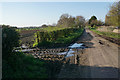
Mud and potholes on Oak Lane
The mud comes from a field entrance near Oak Lane Farm.
Image: © Bill Boaden
Taken: 19 Apr 2018
0.04 miles
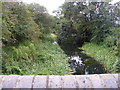
3
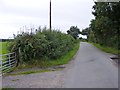
Oak Lane
The view north of the Hatherton Canal bridge near Four Crosses, Staffordshire.
Image: © Gordon Griffiths
Taken: 31 Aug 2012
0.07 miles
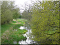
5
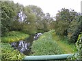
Disused Canal Path
The view east of the disused Hatherton Canal from Oak Lane near Four Crosses, Staffordshire. The canal connected the Staffordshire and Worcestershire Canal to the Cannock Coalfields for 100 years until abandoned in 1955 due to mining subsidence.
Image: © Gordon Griffiths
Taken: 31 Aug 2012
0.11 miles
6
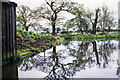
Hatherton canal branch east of Oak Lane in 1986
This is the canal route east of the bridge carrying Oak Lane over the water. Between the two largest trees there's an inlet allowing a water supply for the canal. This branch, (of the Staffs and Worcester Canal), was abandoned in 1955 but for many years a restoration has been ongoing which is a significant undertaking involving some realignment of the original route - https://www.lhcrt.org.uk.
Image: © Trevor Littlewood
Taken: 10 May 1986
0.11 miles
7
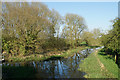
Hatherton Branch Canal
A disused canal which branches off the Staffordshire & Worcestershire Canal. This view is looking east from Oak Lane.
Image: © Bill Boaden
Taken: 19 Apr 2018
0.11 miles
8
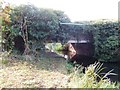
Hatherton Branch Canal - Bridge No 3 - Scrawper's End
The bridge would require reconstruction if the canal is restored to navigation.
Image: © John M
Taken: 13 Nov 2011
0.11 miles
9
Hatherton Branch Canal, near Four Crosses, Staffordshire
Looking back towards the M6 motorway (on which a white vehicle is visible crossing the canal) and Calf Heath. The canal is disused at present, but is gradually being restored with the Lichfield Canal to link the Staffordshire and Worcestershire Canal with the Coventry Canal at Huddlesford Junction, thus reopening many miles of the northern Birmingham Canal Navigation.
Image: © Roger D Kidd
Taken: 26 Apr 2008
0.12 miles
10
Oak Lane Bridge View
The view west of the disused Hatherton Canal near Four Crosses, Staffordshire. The canal connected the Staffordshire and Worcestershire Canal to the Cannock Coalfields for 100 years until abandoned in 1955 due to mining subsidence.
Image: © Gordon Griffiths
Taken: 31 Aug 2012
0.12 miles