IMAGES TAKEN NEAR TO
Lewisham Road, WOLVERHAMPTON, WV10 6SQ
Introduction
This page details the photographs taken nearby to Lewisham Road, WV10 6SQ by members of the Geograph project.
The Geograph project started in 2005 with the aim of publishing, organising and preserving representative images for every square kilometre of Great Britain, Ireland and the Isle of Man.

There are currently over 7.5m images from over14,400 individuals and you can help contribute to the project by visiting https://www.geograph.org.uk
Image Map
Images are licensed for reuse under creativecommons.org/licenses/by-sa/2.0
Notes
- Clicking on the map will re-center to the selected point.
- The higher the marker number, the further away the image location is from the centre of the postcode.
Image Listing (22 Images Found)
Images are licensed for reuse under creativecommons.org/licenses/by-sa/2.0
Image
Details
Distance
1
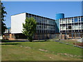
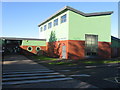
Pendeford Business and Enterprise College
In the northern suburbs of Wolverhampton.
Image: © Derek Harper
Taken: 18 Jul 2006
0.12 miles
2
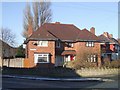
Council Housing - Arundel Road
The Marsh Lane Estate was built in 1937. A feature of the estates of the period were the unattractive concrete block boundary walls. These tend to be retained on properties that have been sold but have been replaced on the refurbished council properties.
Image: © John M
Taken: 25 Dec 2009
0.15 miles
3
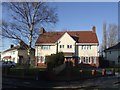
Council Housing - Sandwell Road
The Marsh Lane Estate built in 1937 has had a number of refurbishment schemes including removing the original unattractive grey concrete block boundary walls.
Image: © John M
Taken: 25 Dec 2009
0.18 miles
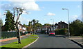
4

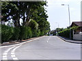
Winchester Road View
The view up Marsh Lane, Fordhouses.
Image: © Gordon Griffiths
Taken: 1 Jul 2009
0.19 miles
5
Harrowby Road, Fordhouses
Suburbia on the northern outskirts of Wolverhampton.
Image: © Jonathan Billinger
Taken: 21 Oct 2008
0.19 miles
6

The Harrowby Arms
The Pub on the corner of Harrowby Road and Patshull Avenue, Fordhouses.
Image: © Gordon Griffiths
Taken: 1 Jul 2009
0.21 miles
8
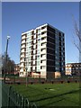
Council Housing - Wobaston Court
One of three 1964 towerblocks on the Chetton Green Estate.
Image: © John M
Taken: 9 Jan 2011
0.21 miles
9
Patshull Avenue
The view from Marsh Lane, Fordhouses
Image: © Gordon Griffiths
Taken: 1 Jul 2009
0.22 miles
10
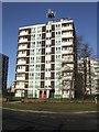
Council Housing - Harrowby Court
The three tower blocks on the Chetton Green Estate were built in 1964. Renovated in 2009 and operated by Wolverhampton Homes to provide sheltered housing for the over 60s.
The estate received a Civic Trust Award in 1966.
http://www.localhistory.scit.wlv.ac.uk/interesting/civic/chettonbosc.htm
Image: © John M
Taken: 9 Jan 2011
0.22 miles