IMAGES TAKEN NEAR TO
Marklin Avenue, WOLVERHAMPTON, WV10 6AE
Introduction
This page details the photographs taken nearby to Marklin Avenue, WV10 6AE by members of the Geograph project.
The Geograph project started in 2005 with the aim of publishing, organising and preserving representative images for every square kilometre of Great Britain, Ireland and the Isle of Man.

There are currently over 7.5m images from over14,400 individuals and you can help contribute to the project by visiting https://www.geograph.org.uk
Image Map
Images are licensed for reuse under creativecommons.org/licenses/by-sa/2.0
Notes
- Clicking on the map will re-center to the selected point.
- The higher the marker number, the further away the image location is from the centre of the postcode.
Image Listing (106 Images Found)
Images are licensed for reuse under creativecommons.org/licenses/by-sa/2.0
Image
Details
Distance
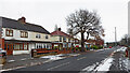
2
Church Road near Oxley in Wolverhampton
Looking west-south-west towards the A449 Stafford Road from near the Wingfoot Park footpath.
The snow is a remnant of the 6-8cm fall dumped by Storm Arwen three days earlier.
Image: © Roger Kidd
Taken: 29 Nov 2021
0.04 miles
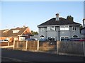
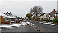
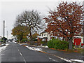
3
Housing in Church Road near Oxley, Wolverhampton
Looking east-north-east towards Three Tuns Lane from the junction with Maybush Gardens.
Image: © Roger Kidd
Taken: 29 Nov 2021
0.04 miles
4
Church Road near Oxley in Wolverhampton
Looking east-north-east towards Three Tuns Lane from the junction with Maybush Gardens.
Image: © Roger Kidd
Taken: 29 Nov 2021
0.04 miles
5
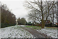
Path to Wingfoot Park near Oxley, Wolverhampton
Looking south-ish from Church Road.
The area to the south has been developed with new housing recently, and this redesigned park (now called Goodyear Neighbourhood Park) opened in 2018.
The snow is a remnant of the 6-8cm fall dumped by Storm Arwen three days earlier.
Image: © Roger Kidd
Taken: 29 Nov 2021
0.04 miles
6
Path in Wingfoot Park near Oxley, Wolverhampton
Looking south-south-west from near Church Road.
The area has been developed with new housing recently, and this redesigned park (now called Goodyear Neighbourhood Park) opened in 2018.
Image: © Roger Kidd
Taken: 29 Nov 2021
0.05 miles
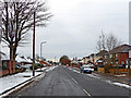
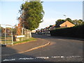
7
Church Road and Marklin Avenue near Oxley, Wolverhampton
Looking west-south-west towards the A449 Stafford Road.
Image: © Roger Kidd
Taken: 29 Nov 2021
0.05 miles
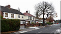
9
Church Road near Oxley in Wolverhampton
Looking west-south-west towards the A449 Stafford Road. Marklin Avenue is off to the left.
Image: © Roger Kidd
Taken: 29 Nov 2021
0.06 miles
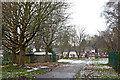
10
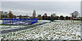
Sports courts in Wingfoot Park, Wolverhampton
These recently constructed courts in Wingfoot Park provide basketball, handball and tennis facilities. The gates were open on this cold day, so I presume free access is available. The area nearby has been developed with new housing recently, and this redesigned park (now called Goodyear Neighbourhood Park) opened in 2018.
The snow is a remnant of the 6-8cm fall dumped by Storm Arwen three days earlier.
Image: © Roger Kidd
Taken: 29 Nov 2021
0.06 miles