IMAGES TAKEN NEAR TO
Leslie Road, WOLVERHAMPTON, WV10 0BU
Introduction
This page details the photographs taken nearby to Leslie Road, WV10 0BU by members of the Geograph project.
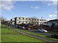
The Geograph project started in 2005 with the aim of publishing, organising and preserving representative images for every square kilometre of Great Britain, Ireland and the Isle of Man.

There are currently over 7.5m images from over14,400 individuals and you can help contribute to the project by visiting https://www.geograph.org.uk
Image Map
Images are licensed for reuse under creativecommons.org/licenses/by-sa/2.0
Notes
- Clicking on the map will re-center to the selected point.
- The higher the marker number, the further away the image location is from the centre of the postcode.
Image Listing (15 Images Found)
Images are licensed for reuse under creativecommons.org/licenses/by-sa/2.0
Image
Details
Distance
1
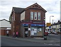
Corner shop at junction of Powell Street and Leslie Road
This looks as if it started life as a public house. The painted signs on the walls are for Butlers Ales.
Image: © John M
Taken: 1 May 2010
0.06 miles
2
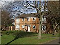
Council Housing - Leslie Street
Small infill estate of houses beside the Cannock Road in Park Village probably dating from the mid 1970s.
Image: © John M
Taken: 13 Nov 2010
0.08 miles
3
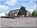
Park Village, youth centre
Park Village Youth, Media & Activity Centre, at the corner of Cannock Road and Park Lane: https://www.facebook.com/pages/Park-Village-Youth-and-Media-Centre/221447827963020?sk=page_map
Image: © Mike Faherty
Taken: 30 Jun 2013
0.12 miles
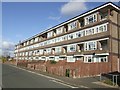
4
Council Housing - Flats in New Park Village
Flats built to replace properties demolished in nearby Park Village.
Image: © John M
Taken: 9 Sep 2006
0.12 miles
5
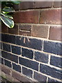
OS benchmark, Park Village former school
An OS cutmark on the front wall of the former school, now the Park Village Youth, Media & Activity Centre (although I have to say, it looked pretty firmly closed the day I passed). Mark originally levelled at 128.571m above Ordnance Datuim Newlyn.
Image: © Richard Law
Taken: 5 Feb 2015
0.13 miles
6
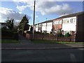
Council Housing - Valley Road
New Park Village was built in the 1970s replacing terraced housing in Park Village. The estate is a mix of flats and terraced housing.
Image: © John M
Taken: 13 Nov 2010
0.15 miles
7
Council Housing - Valley Road
New Park Village was built in the 1970s replacing terraced housing in Park Village.
Image: © John M
Taken: 13 Nov 2010
0.16 miles
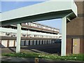
8
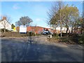
Fallings Park Industrial Estate
The entrance to one of Wolverhampton's many industrial parks
Image: © Richard Law
Taken: 24 Nov 2010
0.19 miles
9
Council Housing - Shawbury Road
New Park Village was built in the 1970s replacing terraced housing in Park Village.
Image: © John M
Taken: 13 Nov 2010
0.21 miles
10
Holy Trinity Almshouses, Heath Town
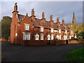
Built around 1850, a terrace of 6 almshouses associated with the Image They were Grade II listed
https://britishlistedbuildings.co.uk/101201798-holy-trinity-almshouses-to-west-of-church-of-holy-trinity-heath-town-ward#.XcJ4Fej7RPY & https://historicengland.org.uk/listing/the-list/list-entry/1201798 in 1977 and rechecked in 1992, at which time they were derelict; clearly they have recently been well restored.
Image: © Richard Law
Taken: 1 Nov 2019
0.22 miles