IMAGES TAKEN NEAR TO
Skip Lane, WALSALL, WS5 3LR
Introduction
This page details the photographs taken nearby to Skip Lane, WS5 3LR by members of the Geograph project.
The Geograph project started in 2005 with the aim of publishing, organising and preserving representative images for every square kilometre of Great Britain, Ireland and the Isle of Man.

There are currently over 7.5m images from over14,400 individuals and you can help contribute to the project by visiting https://www.geograph.org.uk
Image Map
Images are licensed for reuse under creativecommons.org/licenses/by-sa/2.0
Notes
- Clicking on the map will re-center to the selected point.
- The higher the marker number, the further away the image location is from the centre of the postcode.
Image Listing (6 Images Found)
Images are licensed for reuse under creativecommons.org/licenses/by-sa/2.0
Image
Details
Distance
1
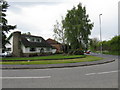
Corner of Park Hall Road and Skip Lane
Park Hall Road is the main route ahead.
Image: © Peter Whatley
Taken: 11 May 2010
0.06 miles
2
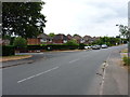
Skip Lane at the junction with Woodside Road
Quite where the name Woodside Road comes from is not clear - maps from the 1930s show the area to the west of Skip Lane as predominantly open fields, albeit with a farm or smallholding marked as 'The Cottage' on the left just about here. No obvious woods to be seen in that direction at all. It's the developer's licence, I suppose.
Image: © Richard Law
Taken: 18 Jul 2018
0.08 miles
3
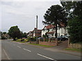
Skip Lane, Great Barr
Part of Skip Lane is still a narrow rural lane however this length towards the south of the square has long since been incorporated in a housing estate.
Image: © David Stowell
Taken: 8 Jul 2006
0.22 miles
4
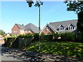
New houses, 1a and 1b Woodfield Close
Image: © Alex McGregor
Taken: 23 Jul 2014
0.24 miles
5
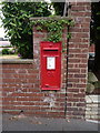
GR wallbox on Park Road
One of many thousands of such, rather plain, 'GR' ciphered wallboxes. Most were manufactured and installed during the reign of King George V, between 1910 and 1936. After his death, and following the short period in 1936 when Edward VII failed to be crowned, surplus stocks of GR boxes were used up during the early years of the reign of George VI. This one is numbered WS5 183D.
Image: © Richard Law
Taken: 18 Jul 2018
0.24 miles
6
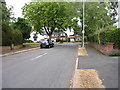
Park Road joins Skip Lane
An area that is mapped as scattered cottages and tree-lined lanes on the maps of the late 1930s. All built up now.
Image: © Richard Law
Taken: 18 Jul 2018
0.24 miles