IMAGES TAKEN NEAR TO
Lichfield Road, WALSALL, WS4 1PQ

Introduction

This page details the photographs taken nearby to Lichfield Road, WS4 1PQ by members of the Geograph project.

The Geograph project started in 2005 with the aim of publishing, organising and preserving representative images for every square kilometre of Great Britain, Ireland and the Isle of Man.

There are currently over 7.5m images from over14,400 individuals and you can help contribute to the project by visiting https://www.geograph.org.uk

Image Map


Images are licensed for reuse under creativecommons.org/licenses/by-sa/2.0
Notes
  • Clicking on the map will re-center to the selected point.
  • The higher the marker number, the further away the image location is from the centre of the postcode.

Image Listing (9 Images Found)

Images are licensed for reuse under creativecommons.org/licenses/by-sa/2.0
Image
Details
Distance
1
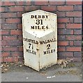
Old Milepost by the A461, Lichfield Road, Shelfield
Cast iron post by the A461, in parish of Walsall (Walsall District), South West of Shelfield, outside No. 298 Lichfield Road, in pavement in front of brick wall, on North West side of road. Derby iron casting, erected by the Walsall Turnpike Trust in the 19th century. Inscription reads:- : LICHFIELD / 7½ / MILES : : DERBY / 31 / MILES : : WALSALL / 2 / MILES : Milestone Society National ID: ST_WLLF02.
Image: © Milestone Society Taken: 30 Jun 2017
0.01 miles
2
Jet Station
The Station stands on the Lichfield Road.
Image: © Gordon Griffiths Taken: 15 Sep 2008
0.01 miles
3
Meadow Close, Shelfield
Image: © Alex McGregor Taken: 21 Oct 2010
0.16 miles
4
Junction of Winterley Lane with Barns Lane
New Street, on the right, is a short road running behind some shops on the main Lichfield Road.
Image: © Richard Law Taken: 24 Oct 2018
0.18 miles
5
Bus stops & road junction
Image: © Row17 Taken: 13 Jun 2009
0.19 miles
6
Barns Lane
Heading east.
Image: © JThomas Taken: 5 Oct 2013
0.22 miles
7
Willows Road
The view on the road off the A461 in Pelsall.
Image: © Gordon Griffiths Taken: 4 May 2013
0.22 miles
8
The Farmers Boy, Barns Lane
Image: © JThomas Taken: 5 Oct 2013
0.23 miles
9
Ford Brook upstream of Pelsall Road
The Ford Brook rises in the Clayhanger/Brownhills area and flows through the centre of Walsall to join the River Tame at Bescot.
Image: © John M Taken: 22 May 2010
0.23 miles