IMAGES TAKEN NEAR TO
Barns Lane, WALSALL, WS4 1HH
Introduction
This page details the photographs taken nearby to Barns Lane, WS4 1HH by members of the Geograph project.
The Geograph project started in 2005 with the aim of publishing, organising and preserving representative images for every square kilometre of Great Britain, Ireland and the Isle of Man.

There are currently over 7.5m images from over14,400 individuals and you can help contribute to the project by visiting https://www.geograph.org.uk
Image Map
Images are licensed for reuse under creativecommons.org/licenses/by-sa/2.0
Notes
- Clicking on the map will re-center to the selected point.
- The higher the marker number, the further away the image location is from the centre of the postcode.
Image Listing (5 Images Found)
Images are licensed for reuse under creativecommons.org/licenses/by-sa/2.0
Image
Details
Distance
4
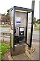
KX200 Telephone Kiosk
Open variant of the KX100 accessible for disabled persons. The notice on the phone suggests that this one will be gone by Christmas.
Image: © John M
Taken: 11 Oct 2016
0.10 miles
5
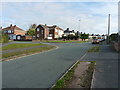
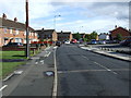
Winterley Lane at the junction with Dean Road
Image: © Richard Law
Taken: 24 Oct 2018
0.25 miles