IMAGES TAKEN NEAR TO
Shireview Gardens, Shireview Road, WALSALL, WS3 4DU
Introduction
This page details the photographs taken nearby to Shireview Gardens, Shireview Road, WS3 4DU by members of the Geograph project.
The Geograph project started in 2005 with the aim of publishing, organising and preserving representative images for every square kilometre of Great Britain, Ireland and the Isle of Man.

There are currently over 7.5m images from over14,400 individuals and you can help contribute to the project by visiting https://www.geograph.org.uk
Image Map
Images are licensed for reuse under creativecommons.org/licenses/by-sa/2.0
Notes
- Clicking on the map will re-center to the selected point.
- The higher the marker number, the further away the image location is from the centre of the postcode.
Image Listing (5 Images Found)
Images are licensed for reuse under creativecommons.org/licenses/by-sa/2.0
Image
Details
Distance
1
Play Ground
Children's playground, on part of the old railway line that ran to Pelsall.
Image: © martin bowerman
Taken: 14 Dec 2008
0.09 miles
2
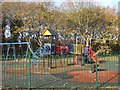
Playground in the clearing
Surrounded on four sides by trees.
Image: © John M
Taken: 27 Nov 2011
0.18 miles
3
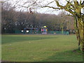
Pelsall Village Common
Looking towards the houses and shops on Norton Road.
Image: © Adrian Rothery
Taken: 5 Oct 2007
0.21 miles
4
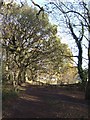
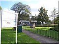
Timberland Trail - Forest of Mercia
Former trackbed of a colliery railway.
Image: © John M
Taken: 27 Nov 2011
0.22 miles