IMAGES TAKEN NEAR TO
Bloxwich Road, WALSALL, WS3 2XE

Introduction

This page details the photographs taken nearby to Bloxwich Road, WS3 2XE by members of the Geograph project.

The Geograph project started in 2005 with the aim of publishing, organising and preserving representative images for every square kilometre of Great Britain, Ireland and the Isle of Man.

There are currently over 7.5m images from over14,400 individuals and you can help contribute to the project by visiting https://www.geograph.org.uk

Image Map


Images are licensed for reuse under creativecommons.org/licenses/by-sa/2.0
Notes
  • Clicking on the map will re-center to the selected point.
  • The higher the marker number, the further away the image location is from the centre of the postcode.

Image Listing (12 Images Found)

Images are licensed for reuse under creativecommons.org/licenses/by-sa/2.0
Image
Details
Distance
1
Cope Street, Bloxwich
Image: © Alex McGregor Taken: 19 Apr 2011
0.07 miles
2
Furniture Corner
The view of the shops on Bloxwich Road in Harden, Walsall.
Image: © Gordon Griffiths Taken: 29 May 2014
0.07 miles
3
Leamore Lane Shops
The view in Harden, Walsall.
Image: © Gordon Griffiths Taken: 29 May 2014
0.08 miles
4
Bloxwich Road Lights
The view of the road junction with Leamore Lane in Walsall.
Image: © Gordon Griffiths Taken: 29 May 2014
0.10 miles
5
Terraced housing on May Street
A row of terraced houses, leading up to the B4210 Bloxwich Road.
Image: © Richard Law Taken: 18 Feb 2013
0.13 miles
6
Housing in Providence Lane, Bloxwich
1930's and 1960's styles next to each other.
Image: © Jonathan Billinger Taken: 1 May 2008
0.16 miles
7
Housing between Leamore and Harden
Beatrice Street leads off to the left, whilst Portsea Street runs uphill towards the flats a bit further up the road.
Image: © Richard Law Taken: 18 Feb 2013
0.17 miles
8
Housing on Bagnall Street
Houses and semis on Bagnall Street, Leamore.
Image: © Richard Law Taken: 18 Feb 2013
0.21 miles
9
OS benchmark - Blakenall Heath, 15 Guild Avenue
An OS cutmark located on the front wall of a house on Guild Avenue; originally levelled, probably in 1957, at 159.673m above Ordnance Datum Newlyn.
Image: © Richard Law Taken: 27 Sep 2016
0.21 miles
10
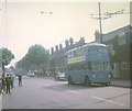
Walsall trolleybus in Bloxwich Road, Leamore
Crossley Empire TDD43/2 trolleybus 850 (HBE 541) on a private tour in Bloxwich Road, Leamore approaching the "Red Lion" public house.
Image: © David Hillas Taken: 20 Sep 1969
0.23 miles