IMAGES TAKEN NEAR TO
Beatrice Street, WALSALL, WS3 2AB
Introduction
This page details the photographs taken nearby to Beatrice Street, WS3 2AB by members of the Geograph project.
The Geograph project started in 2005 with the aim of publishing, organising and preserving representative images for every square kilometre of Great Britain, Ireland and the Isle of Man.

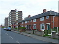
There are currently over 7.5m images from over14,400 individuals and you can help contribute to the project by visiting https://www.geograph.org.uk
Image Map
Images are licensed for reuse under creativecommons.org/licenses/by-sa/2.0
Notes
- Clicking on the map will re-center to the selected point.
- The higher the marker number, the further away the image location is from the centre of the postcode.
Image Listing (19 Images Found)
Images are licensed for reuse under creativecommons.org/licenses/by-sa/2.0
Image
Details
Distance
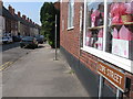
1
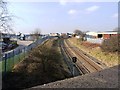
Railway line towards Walsall
The line from Bloxwich, looking towards Walsall, with the rear of the houses on Beatrice Street on the left.
Image: © Richard Law
Taken: 18 Feb 2013
0.03 miles
2
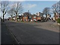
Housing on Bagnall Street
Houses and semis on Bagnall Street, Leamore.
Image: © Richard Law
Taken: 18 Feb 2013
0.05 miles
3
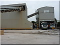
Lafarge Tarmac readymix plant in Walsall
Image: © Richard Law
Taken: 23 Aug 2013
0.07 miles
4
Housing in Providence Lane, Bloxwich
1930's and 1960's styles next to each other.
Image: © Jonathan Billinger
Taken: 1 May 2008
0.07 miles
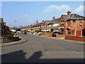
5
Housing between Leamore and Harden
Beatrice Street leads off to the left, whilst Portsea Street runs uphill towards the flats a bit further up the road.
Image: © Richard Law
Taken: 18 Feb 2013
0.08 miles
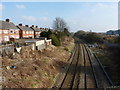
6
Railway line towards Bloxwich
The line from Walsall to Bloxwich, from where it runs onwards to Great Wyrley and Hednesford, before joining the main line at Rugeley.
Image: © Richard Law
Taken: 18 Feb 2013
0.10 miles
7
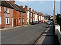
Terraced housing on May Street
A row of terraced houses, leading up to the B4210 Bloxwich Road.
Image: © Richard Law
Taken: 18 Feb 2013
0.13 miles
8
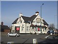
Four Crosses Public House
A Marston's pub on the A34 Walsall to Cannock road. Marston's is now the company name for the former Wolverhampton & Dudley Breweries business. Many of the pubs have been re-branded from the Banks's and Hanson's name.
Image: © John M
Taken: 8 Mar 2009
0.16 miles
9
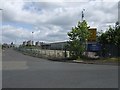
Powerhouse Depot (closed)
Powerhouse Retail Group went in to administration in August 2003. The business was sold without liabilities and traded as PRG Powerhouse Retail Group until it also went in to administration in August 2006 leading to the closure of the remaining shops. At the time it was the third largest electrical retailer.
Powerhouse had developed from the high street shops operated by the electricity companies including MEB and Scottish Power.
Image: © John M
Taken: 22 Jun 2008
0.16 miles