IMAGES TAKEN NEAR TO
Stephenson Avenue, WALSALL, WS2 7DP
Introduction
This page details the photographs taken nearby to Stephenson Avenue, WS2 7DP by members of the Geograph project.
The Geograph project started in 2005 with the aim of publishing, organising and preserving representative images for every square kilometre of Great Britain, Ireland and the Isle of Man.

There are currently over 7.5m images from over14,400 individuals and you can help contribute to the project by visiting https://www.geograph.org.uk
Image Map
Images are licensed for reuse under creativecommons.org/licenses/by-sa/2.0
Notes
- Clicking on the map will re-center to the selected point.
- The higher the marker number, the further away the image location is from the centre of the postcode.
Image Listing (15 Images Found)
Images are licensed for reuse under creativecommons.org/licenses/by-sa/2.0
Image
Details
Distance
1
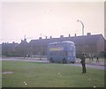
Walsall Trolleybus near Fleming Road
Crossley Empire TDD43/2 trolleybus 850 (HBE541) on a private tour in Stephenson Avenue near Fleming Road at Leamore North of Walsall.
Image: © David Hillas
Taken: 20 Sep 1969
0.04 miles
2
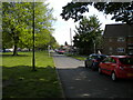
Eastern half of Fleming Road, Beechdale estate
Seen from Stephenson Avenue, which cuts Fleming Road in half.
Image: © Richard Vince
Taken: 29 May 2021
0.05 miles
3
Stephenson Avenue service road, Beechdale estate (2)
Seen at its junction with the western half of Fleming Road, whose other half is on the other side of the green space on the left (which also separates the service road from Stephenson Avenue proper).
Image: © Richard Vince
Taken: 29 May 2021
0.06 miles
4
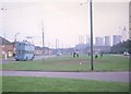
Walsall trolleybus at Leamore
Pictured in Stephenson Avenue, Walsall trolleybus 850 (HBE541) is on a private trip. The power station chimneys in the right background disappeared somewhile ago.
Image: © David Hillas
Taken: 20 Sep 1969
0.06 miles
5
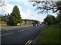
Stephenson Avenue, Beechdale estate
One of the main distributor roads in the estate, whose road names have a scientists and inventors theme. Seen from close to its north west end, where it meets Bloxwich Lane (just behind the photographer).
Image: © Richard Vince
Taken: 29 May 2021
0.07 miles
6
Stephenson Avenue service road, Beechdale estate (1)
Separated from Stephenson Avenue proper by the broad strip of green space on the left. Seen from close to its junction with Bloxwich Lane.
Image: © Richard Vince
Taken: 29 May 2021
0.08 miles
7
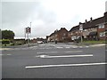
Fleming Road
The view from Leamore Lane in Walsall.
Image: © Gordon Griffiths
Taken: 29 May 2014
0.08 miles
8
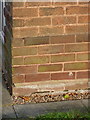
OS benchmark - 29 Bloxwich Lane
An OS cutmark in the bricks of 29 Bloxwich Lane, originally levelled at 135.471m above Ordnance Datum Newlyn.
Image: © Richard Law
Taken: 5 Sep 2013
0.09 miles
9
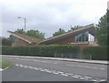
Hatherton Children's Centre
Timber building with a living roof covering.
Image: © John M
Taken: 16 May 2009
0.09 miles
10
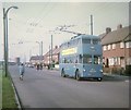
Walsall Trolleybus in Stephenson Avenue
Crossley-Empire trolleybus 850 (HBE 541) on a private tour travelling towards Walsall. The vehicle came from Grimsby-Cleethorpes Transport in 1961 after the trolleybus system was abandoned there.
Image: © David Hillas
Taken: 20 Sep 1969
0.09 miles