IMAGES TAKEN NEAR TO
Sandy Lane, RUGELEY, WS15 2LF
Introduction
This page details the photographs taken nearby to Sandy Lane, WS15 2LF by members of the Geograph project.
The Geograph project started in 2005 with the aim of publishing, organising and preserving representative images for every square kilometre of Great Britain, Ireland and the Isle of Man.

There are currently over 7.5m images from over14,400 individuals and you can help contribute to the project by visiting https://www.geograph.org.uk
Image Map
Images are licensed for reuse under creativecommons.org/licenses/by-sa/2.0
Notes
- Clicking on the map will re-center to the selected point.
- The higher the marker number, the further away the image location is from the centre of the postcode.
Image Listing (20 Images Found)
Images are licensed for reuse under creativecommons.org/licenses/by-sa/2.0
Image
Details
Distance
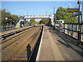
4
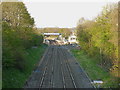
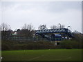
Rugeley Town station from the Sandy Lane / Hednesford Road bridge
Image: © Richard Law
Taken: 2 May 2013
0.06 miles
5
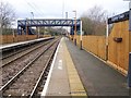
Rugeley Town railway station, Staffordshire
Opened in 1997 by British Rail on the line from Walsall to Rugeley Trent Valley station. A previous Rugeley station existed 1870-1965 around 250m behind the camera position.
View south west towards Brindley Heath and Walsall, shortly after the railway line was electrified.
Image: © Nigel Thompson
Taken: 25 Jan 2019
0.10 miles
6
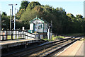
Brereton sidings signal box
This is the signal box at Rugeley Town station that controls the access into Rugeley Power Station and the passenger service to Rugeley Town. Its days are numbered as the Cannock line is being re-signalled and all this line will be controlled from the West Midlands signalling centre.
Image: © roger geach
Taken: 4 Oct 2012
0.10 miles
7
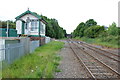
Brereton Sidings Signal Box
Looking from Rugeley Station towards Hednesford.
Image: © Mick Malpass
Taken: 27 May 2011
0.10 miles
8
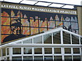
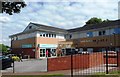
Lea Hall Miners' Welfare Centre & Social Club
Lea Hall is a large social club in Rugeley. Many of its 1,500 members are former miners. As part of the redevelopment of the entrance area the members and committee raised money to commission a piece of public art for the front of the building.
Image: © A Holmes
Taken: 19 Apr 2008
0.11 miles
9
Rugeley Town railway station, Staffordshire, 2011
Opened in 1997 by British Rail on the line from Walsall to Rugeley Trent Valley station. A previous Rugeley station existed 1870-1965 around 250m beyond the end of the platforms.
View north east towards Rugeley Trent Valley, some 7 years before the railway line was electrified. See Image for a 2019 view in the opposite direction.
Image: © Nigel Thompson
Taken: 22 Oct 2011
0.11 miles