IMAGES TAKEN NEAR TO
Arch Street, RUGELEY, WS15 2JU
Introduction
This page details the photographs taken nearby to Arch Street, WS15 2JU by members of the Geograph project.
The Geograph project started in 2005 with the aim of publishing, organising and preserving representative images for every square kilometre of Great Britain, Ireland and the Isle of Man.

There are currently over 7.5m images from over14,400 individuals and you can help contribute to the project by visiting https://www.geograph.org.uk
Image Map
Images are licensed for reuse under creativecommons.org/licenses/by-sa/2.0
Notes
- Clicking on the map will re-center to the selected point.
- The higher the marker number, the further away the image location is from the centre of the postcode.
Image Listing (132 Images Found)
Images are licensed for reuse under creativecommons.org/licenses/by-sa/2.0
Image
Details
Distance
1
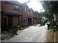
Keystone Road, Rugeley
In my childhood, this was Keystone Lane, but it has morphed into Keystone Road. On this site the Key family had a factory. Now there is a small housing development, Keystone Mews.
In the late 1870s John Key had a draper’s shop in nearby Lower Brook Street.In 1888 his son George set up his own business on the second floor. Later that year George introduced a new type of coat made of thick, hard-wearing material, which he had developed for the navvies who were building the Manchester Ship Canal. The coat became known as the Donkey Jacket – named after the ‘donkey engines’ that some of the navvies worked on. The mail order business, now so popular, was pioneered by George Key through his catalogue, The Keystone. Ladies’ clothes were sold by mail order after the First World War, and the firm lasted until 1984.
The Wikipedia entry for donkey jacket tells none of this. I obtained it from a local heritage site for Rugeley so I hope it's accurate.
Image: © Tricia Neal
Taken: 19 Oct 2013
0.03 miles
3
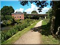
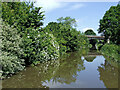
Canal bridges
The Trent and Mersey Canal at Rugeley.
Image: © Patrick Mackie
Taken: 28 Aug 2006
0.06 miles
4
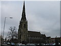
St Paul's church
A small church in the centre of Rugeley, just off the appropriately named St Paul's Road.
Image: © Richard Law
Taken: 2 May 2013
0.08 miles
5
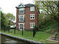
Canalside flats at Town Wharf, Rugeley
There used to be a small canal basin near here, so the street name may be appropriate.
Image: © Christine Johnstone
Taken: 2 May 2022
0.10 miles
7
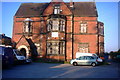
A Grand Billiards Club
Rugeley Billiards Club on Heron Street is in a magnificent old house that to me looks like an old manor house.
Image: © Stephen Pearce
Taken: 7 Nov 2006
0.11 miles
8
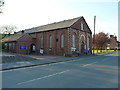
St Paul's Church Hall, Rugeley
The hall is right opposite the church of the same name on St Paul's Road Image Thursday 2nd May was a local government election day, so the hall was being used as a polling station.
Image: © Richard Law
Taken: 2 May 2013
0.11 miles
9
Trent and Mersey Canal approaching Rugeley in Staffordshire
Looking north towards Rugeley town centre. Ahead are two railway bridges, the first being disused.
Image: © Roger Kidd
Taken: 20 Jun 2010
0.11 miles
10
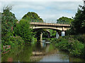
Bridges across the canal near Rugeley, Staffordshire
The first bridge carried a now dismantled railway line to the power station. The far one carries the passenger line to Stafford (or Stone).
Image: © Roger Kidd
Taken: 30 Aug 2013
0.11 miles