IMAGES TAKEN NEAR TO
Bassett Road, WEDNESBURY, WS10 0LY
Introduction
This page details the photographs taken nearby to Bassett Road, WS10 0LY by members of the Geograph project.
The Geograph project started in 2005 with the aim of publishing, organising and preserving representative images for every square kilometre of Great Britain, Ireland and the Isle of Man.

There are currently over 7.5m images from over14,400 individuals and you can help contribute to the project by visiting https://www.geograph.org.uk
Image Map
Images are licensed for reuse under creativecommons.org/licenses/by-sa/2.0
Notes
- Clicking on the map will re-center to the selected point.
- The higher the marker number, the further away the image location is from the centre of the postcode.
Image Listing (4 Images Found)
Images are licensed for reuse under creativecommons.org/licenses/by-sa/2.0
Image
Details
Distance
1
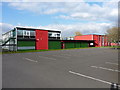
Parking area at the Phoenix Collegiate
The Phoenix Collegiate is a new school, formed in 2010 after the closure and merger of two former schools in Sandwell, the Manor (on this site) and the Menzies.
Image: © Richard Law
Taken: 19 Apr 2013
0.12 miles
2
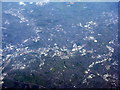
Wednesbury from the air
Looking west from near Royal Sutton Coldfield. A landscape of industrial estates. The stadium at lower right is the home of Walsall FC. The major road at the bottom of the picture is the M5[L] and M6[R] - the M6 continues to the east, 'down' out of the picture.
Image: © M J Richardson
Taken: 4 May 2016
0.13 miles
3
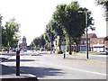
Friar Park
The central boulevard of this council estate - that shares its name with George Harrison's stately pile - looking west past the shops towards the Church of the Ascension. Do F1 drivers come here to practise chicanes?
Image: © Adrian Bailey
Taken: 21 Aug 2005
0.18 miles
4
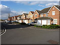
Housing on the north side of Friar Park
A new housing development between the older Friar Park area and the M6 near the Bescot railfreight yard.
Image: © Richard Law
Taken: 19 Apr 2013
0.23 miles