IMAGES TAKEN NEAR TO
Ford Lane, DROITWICH, WR9 0BH
Introduction
This page details the photographs taken nearby to Ford Lane, WR9 0BH by members of the Geograph project.
The Geograph project started in 2005 with the aim of publishing, organising and preserving representative images for every square kilometre of Great Britain, Ireland and the Isle of Man.

There are currently over 7.5m images from over14,400 individuals and you can help contribute to the project by visiting https://www.geograph.org.uk
Image Map
Images are licensed for reuse under creativecommons.org/licenses/by-sa/2.0
Notes
- Clicking on the map will re-center to the selected point.
- The higher the marker number, the further away the image location is from the centre of the postcode.
Image Listing (19 Images Found)
Images are licensed for reuse under creativecommons.org/licenses/by-sa/2.0
Image
Details
Distance
1
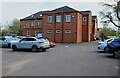
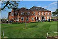
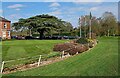
Westford House (2), Ford Lane, Droitwich Spa, Worcs
Westwood House is the Clubhouse for Droitwich Golf Club. This is the back view which seems to include a modern extension.
See also:- Image
Image: © P L Chadwick
Taken: 18 Apr 2023
0.01 miles
2
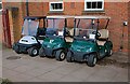
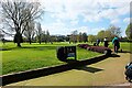
Golf Buggies, Droitwich Golf Club, Ford Lane, Droitwich Spa, Worcs
These battery powered golf buggies (or golf carts) are parked by one of the external walls of the Clubhouse. Near them are wall-mounted charging points.
Image: © P L Chadwick
Taken: 18 Apr 2023
0.01 miles
3
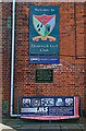
Signs on Westford House, Droitwich Golf Course, Ford Lane, Droitwich Spa, Worcs
These signs are to be found on the eastern wall of the Clubhouse, Westf0rd House.
Image
Image: © P L Chadwick
Taken: 18 Apr 2023
0.01 miles
4
Westford House (1), Ford Lane, Droitwich Spa, Worcs
Westwood House is the Clubhouse for Droitwich Golf Club (formerly Droitwich Golf & Country Club). It is one of two golf clubs located near to the town. Founded in 1897 with a 9 hole course, it was redesigned and extended to 18 holes in the early 1920's. The course is located in attractive Worcestershire countryside with nearby access from the A38 and the M5 motorway.
The Clubhouse was built in 1830 as a private residence. It has had other uses including use as a Red Cross Hospital in World War I. It was taken over by the club in 1924 and includes a bar and restaurant along with other facilities.
Image
Image: © P L Chadwick
Taken: 18 Apr 2023
0.01 miles
5
View to the east, by the Clubhouse, Droitwich Golf Course, Ford Lane, Droitwich Spa, Worcs
This view includes the three flagpoles with flags.
Image: © P L Chadwick
Taken: 18 Apr 2023
0.02 miles
6
Tee for first hole, Droitwich Golf Club, Ford Lane, Droitwich Spa, Worcs
The tee for the first hole on Droitwich Golf Club's attractive 18 hole course.
Image: © P L Chadwick
Taken: 18 Apr 2023
0.04 miles
7
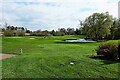
Droitwich Golf Course with water feature, Ford Lane, Droitwich Spa, Worcs
Droitwich Golf Club's 18 hole course includes this water feature, which incorporates a small fountain.
Image: © P L Chadwick
Taken: 18 Apr 2023
0.05 miles
8
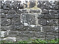
Old Bridge Marker on Ford Bridge, Upper Ford
Bridge Marker set in the parapet of Ford Bridge, River Salwarpe, on the northeast side of Ford Lane. Dodderhill parish.
Milestone Society National ID: WO_DODDER01br
Image: © Roadside Relics
Taken: 28 Jan 2023
0.08 miles
9
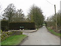
Ford Lane At The Golf Course Entrance
Image: © Peter Whatley
Taken: 23 Mar 2010
0.12 miles
10
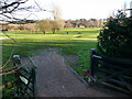
Golf course (2)
Looking across the golf course to the club house in the distance, showing the gate out onto the road, which leads to the rest of the course on the opposite side of Crutch Lane, the old roman road north out of Droitwich. See Image
Image: © Mike Dodman
Taken: 10 Dec 2008
0.12 miles