IMAGES TAKEN NEAR TO
Woodmancote, WORCESTER, WR8 9BP
Introduction
This page details the photographs taken nearby to Woodmancote, WR8 9BP by members of the Geograph project.
The Geograph project started in 2005 with the aim of publishing, organising and preserving representative images for every square kilometre of Great Britain, Ireland and the Isle of Man.

There are currently over 7.5m images from over14,400 individuals and you can help contribute to the project by visiting https://www.geograph.org.uk
Image Map
Images are licensed for reuse under creativecommons.org/licenses/by-sa/2.0
Notes
- Clicking on the map will re-center to the selected point.
- The higher the marker number, the further away the image location is from the centre of the postcode.
Image Listing (26 Images Found)
Images are licensed for reuse under creativecommons.org/licenses/by-sa/2.0
Image
Details
Distance
1
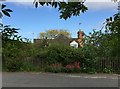
Old Toll House by the A4104, Woodmancote
Defford Toll House by the A4104, in parish of Defford (Wychavon District), Turnpike Cottage (Turnpike Kennels), Woodmancote, WR8 9BP.
Worcestershire and Worcester City HER.
HER Reference: WSM35509 https://www.heritagegateway.org.uk/Gateway/Results_Single.aspx?uid=MWR15786&resourceID=1035
To be surveyed
Milestone Society National ID: WO.DEF
Image: © Alan Rosevear
Taken: 6 Jun 2015
0.00 miles
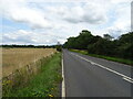
2
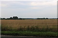
Road near Red Deer Farm
Country road to the east of Dunstall Common near Red Deer Farm.
Image: © Philip Halling
Taken: 4 Jun 2016
0.06 miles
3
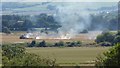
Straw burning
Straw burning on the site of the former RAF Defford.
Image: © Philip Halling
Taken: 29 Aug 2016
0.10 miles
4
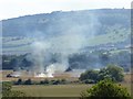
Straw burning
Straw burning on the site of the former RAF Defford; Bredon Hill, including Parsons' Folly on its summit can be seen in the background.
Image: © Philip Halling
Taken: 29 Aug 2016
0.10 miles
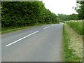
5
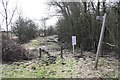
Bridleway on Marsh Common
The very northern point of Marsh Common is just wide enough for a route-way.
Before the turnpike trusts put the A-road across the common this would have been the road; now merely a bridleway.
On the right is Marsh Covert and on the left is Wychavon District.
The common, though, is under the bye-laws of Malvern Hills District Council and they are laid out for all to see on the noticeboard.
Image: © Bob Embleton
Taken: 21 Mar 2010
0.11 miles
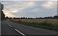
8
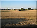
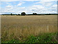
Harvested wheat field beside Defford Airfield
This field to the north of the A4104 has been harvested and the straw bales collected. The satellite station on the former Defford airfield can be seen in the background.
Image: © Philip Halling
Taken: 2 Sep 2010
0.12 miles