IMAGES TAKEN NEAR TO
Egdon, WORCESTER, WR7 4QP
Introduction
This page details the photographs taken nearby to WR7 4QP by members of the Geograph project.
The Geograph project started in 2005 with the aim of publishing, organising and preserving representative images for every square kilometre of Great Britain, Ireland and the Isle of Man.

There are currently over 7.5m images from over14,400 individuals and you can help contribute to the project by visiting https://www.geograph.org.uk
Image Map
Images are licensed for reuse under creativecommons.org/licenses/by-sa/2.0
Notes
- Clicking on the map will re-center to the selected point.
- The higher the marker number, the further away the image location is from the centre of the postcode.
Image Listing (5 Images Found)
Images are licensed for reuse under creativecommons.org/licenses/by-sa/2.0
Image
Details
Distance
1
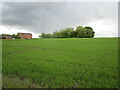
Ominous clouds at Upper Wolverton
We did indeed get very wet.
Image: © Jonathan Thacker
Taken: 24 May 2021
0.03 miles
3

Winter cereals at Stoulton
Winter sun on a field of winter cereals near Stoulton. In silhouette on the horizon is Stoulton church.
Image: © Philip Halling
Taken: 13 Dec 2009
0.19 miles
4
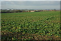
Arable land near Stoulton
View across arable land to the east of Stoulton, on the right in the middle distance is Mucknell Farm, currently being redeveloped, and in the distance are industrial units at Norton.
Image: © Philip Halling
Taken: 13 Dec 2009
0.19 miles
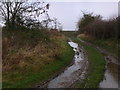
5
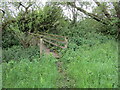
Footbridge over a drain
With recent heavy rainfall it wasn't entirely surprising to find the path beyond this bridge impassable. I knew the game was up when my Jack Russell Terrier started swimming!
Image: © Jonathan Thacker
Taken: 24 May 2021
0.24 miles