IMAGES TAKEN NEAR TO
Chesterton Gardens, WORCESTER, WR5 1SR
Introduction
This page details the photographs taken nearby to Chesterton Gardens, WR5 1SR by members of the Geograph project.
The Geograph project started in 2005 with the aim of publishing, organising and preserving representative images for every square kilometre of Great Britain, Ireland and the Isle of Man.

There are currently over 7.5m images from over14,400 individuals and you can help contribute to the project by visiting https://www.geograph.org.uk
Image Map
Images are licensed for reuse under creativecommons.org/licenses/by-sa/2.0
Notes
- Clicking on the map will re-center to the selected point.
- The higher the marker number, the further away the image location is from the centre of the postcode.
Image Listing (618 Images Found)
Images are licensed for reuse under creativecommons.org/licenses/by-sa/2.0
Image
Details
Distance
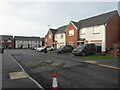
1
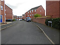
Chesterton Gardens, Worcester
Seen from Darwin Avenue. This development is on one end of what was the former Ronkswood Hospital site.
Image: © Chris Allen
Taken: 24 Mar 2021
0.02 miles
2

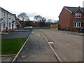
Darwin Avenue, Worcester
Seen from Newtown Road. This development was on the edge of the Ronkswod Hospital site and was the first part of the site to be redeveloped.
Image: © Chris Allen
Taken: 1 Dec 2020
0.03 miles
3
Reinstated public footpath from Aconbury Close
This is the path through the Stableford development and continues from the end of the street into Darwin Field beyond. This has only just reopened to the public.
Image: © Chris Allen
Taken: 27 Mar 2021
0.04 miles
4
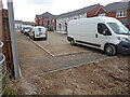
Stableford development, Worcester
A new housing development off Newtown Road, Worcester. This corner appears nearly finished. On the extreme left is the original gate for the public footpath that crossed the site. This is being reinstated on a slightly different alignment but I am not sure that it is open yet so I ventured no further, although there was no barrier here.
Image: © Chris Allen
Taken: 24 Mar 2021
0.05 miles
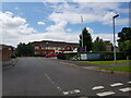
5
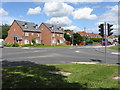
New houses on Newtown Road
At the traffic light controlled junction with Canterbury Road.
Image: © Peter Whatley
Taken: 23 Jun 2008
0.05 miles
6
Augusta Drive, Stableford Development, Worcester
This new housing development is now receiving the finishing touches with completion of the road surface and pavements.
Image: © Chris Allen
Taken: 26 Nov 2022
0.05 miles
7
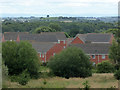
Houses on Darwin Avenue, Worcester
These are on part of the former Ronkswood Hospital site and are seen from the lower slopes of Leopard Hill. The lone tree on the horizon is above Crookbarrow Farm and is visible from the northbound M5 approaching Junction 7 for quite some distance.
Image: © Chris Allen
Taken: 18 Aug 2020
0.05 miles
8

Temporary access road to Stableford development
At least I hope it is temporary while work is being undertaken on the access from Newtown Road. This access is from Aconbury Close and is also across a footpath that is currently closed (again I hope that is temporary).
Image: © Chris Allen
Taken: 11 Aug 2020
0.05 miles
9
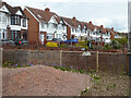
Housing on Newtown Road, Worcester
Some quite distinguished older housing stock alongside one of the roads leading away from the city centre. This view is from the pavement and does not involve trespass - a little zoom has made it appear closer.
Image: © Chris Allen
Taken: 2 May 2021
0.05 miles
10
Latimer Court Care Home, Darwin Avenue, Worcester
Image: © Jeff Gogarty
Taken: 13 Jun 2022
0.06 miles