IMAGES TAKEN NEAR TO
Little Piece, WORCESTER, WR4 0RR
Introduction
This page details the photographs taken nearby to Little Piece, WR4 0RR by members of the Geograph project.
The Geograph project started in 2005 with the aim of publishing, organising and preserving representative images for every square kilometre of Great Britain, Ireland and the Isle of Man.

There are currently over 7.5m images from over14,400 individuals and you can help contribute to the project by visiting https://www.geograph.org.uk
Image Map
Images are licensed for reuse under creativecommons.org/licenses/by-sa/2.0
Notes
- Clicking on the map will re-center to the selected point.
- The higher the marker number, the further away the image location is from the centre of the postcode.
Image Listing (101 Images Found)
Images are licensed for reuse under creativecommons.org/licenses/by-sa/2.0
Image
Details
Distance
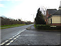
1
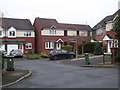
Little Piece, Lyppard-Woodgreen
Seen from Debdale Avenue in this section of Warndon Villages.
Image: © Chris Allen
Taken: 24 Jan 2020
0.02 miles
2
Windles Row, Lyppard-Woodgreen
Part of Warndon Villages. I have just come through from Trotshill Lane West on a short footpath. The various subdivisions of the villages are cul-de-sacs by car but linked by footpaths and cycleways.
Image: © Chris Allen
Taken: 25 Oct 2021
0.02 miles
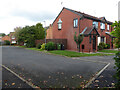
3
Windles Row, Lyppard- Woodgreen
Street names are essential for locating these pictures taken without GPS. The photographer is looking in from Debdale Avenue. The rather exuberant hedge on the left is hiding further houses.
Image: © Chris Allen
Taken: 6 Oct 2019
0.03 miles
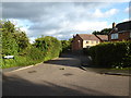
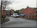
4
Play area on Debdale Avenue, Lyppard-Woodgreen
The road to the left is Little Piece. In the background and moving to the left is Windles Row while Debdale Avenue turns to the right.
Image: © Chris Allen
Taken: 24 Jan 2020
0.03 miles
5
Junction of Debdale Avenue and Mill Wood Drive
This is the part of Warndon Villages known as The Lyppards. Mill Wood Drive is one of the major routes between several of the Lyppards while Debdale Avenue, leading off to the right, is the entrance to Lyppard-Woodgreen. Straight across Mill Wood Drive opposite Debdale Avenue is a foot path leading into Lyppard-Huxley.
Image: © Chris Allen
Taken: 15 Dec 2019
0.05 miles
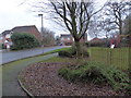
6
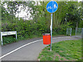
Trotshill Lane west, Worcester
At its origin from Millwood Drive. Trotshill Lane is a former road that has been buried in a modern development and downgraded in parts to a footpath and cycleway. Parts are accessible to cars but there is no longer a through route.
Image: © Chris Allen
Taken: 2 May 2021
0.05 miles
7
Millhams Avenue, Lyppard-Woodgreen
Race Field is seen leading off to the right in the background while Millhams Avenue curves to the left. The view is from Debdale Avenue. Most of my photographs of Warndon Villages are taken from the vicinity of road junctions.
Image: © Chris Allen
Taken: 15 Dec 2019
0.05 miles
8
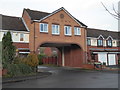
Lord's Heath, Lyppard-Woodgreen
This named street is through this archway off Debdale Avenue. Warndon Villages seem never-ending and the number of different meaningful views seems a fairly large number also, without resorting to individual houses, which I would think overly intrusive.
Image: © Chris Allen
Taken: 15 Dec 2019
0.05 miles
9
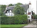
A thatched house in Worcester
Buried among masses of new housing is this pretty thatched house that is on Trotshill Lane West. Trotshill Lane is one of the old roads that predate Warndon Villages and there are older properties, including a former farm, associated with it. A new road divides it into West and East Portions and some sections are pedestrian access only.
Image: © Chris Allen
Taken: 6 Oct 2019
0.06 miles
10
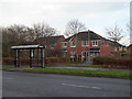
Mill Wood Drive, The Lyppards
View across Millwood Drive to the Debdale Avenue bus stop and the houses of Lyppard-Huxley on Fallow Field beyond the hedge. A short path leads from Mill Wood Drive into Lyppard-Huxley.
Image: © Chris Allen
Taken: 15 Dec 2019
0.06 miles