IMAGES TAKEN NEAR TO
Pirie Avenue, WORCESTER, WR4 0NE
Introduction
This page details the photographs taken nearby to Pirie Avenue, WR4 0NE by members of the Geograph project.
The Geograph project started in 2005 with the aim of publishing, organising and preserving representative images for every square kilometre of Great Britain, Ireland and the Isle of Man.

There are currently over 7.5m images from over14,400 individuals and you can help contribute to the project by visiting https://www.geograph.org.uk
Image Map
Images are licensed for reuse under creativecommons.org/licenses/by-sa/2.0
Notes
- Clicking on the map will re-center to the selected point.
- The higher the marker number, the further away the image location is from the centre of the postcode.
Image Listing (119 Images Found)
Images are licensed for reuse under creativecommons.org/licenses/by-sa/2.0
Image
Details
Distance
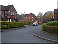
1
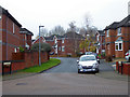
Pirie avenue, Harley Bakewell
In the distance is the street sign on the junction with McCormick Avenue. I don't have GPS so I rely on trying to keep street names in shot and maintaining a flow through these estates so I can retrace my steps on the aerial views and Streetview. There is a bewildering number of junctions in the various areas that comprise Warndon Villages and there are days of fun to be had still. This was my first foray into Harley Bakewell and there are many junctions to explore yet.
Image: © Chris Allen
Taken: 24 Nov 2019
0.02 miles
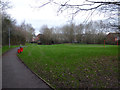
2
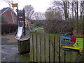
Pirie Avenue play area, Harley-Bakewell
One of several play areas scattered across Warndon Villages.
Image: © Chris Allen
Taken: 9 Jan 2020
0.04 miles
3
Dunmow Avenue, Harley-Bakewell, Worcester
Seen from Fowler Avenue.
Image: © Chris Allen
Taken: 24 Nov 2019
0.05 miles
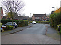
4
McCormick Avenue, Harley-Bakewell
Seen from the footpath that runs between Harley-Warren and Harley-Bakewell.
Image: © Chris Allen
Taken: 9 Jan 2020
0.05 miles
5
Hobhouse Gardens, Harley Bakewell
Photographed from Dunmow Avenue.
Image: © Chris Allen
Taken: 24 Nov 2019
0.05 miles
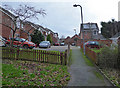
6
Playing field, Harley-Bakewell
One of many variably sized green areas in and between the various Warndon Villages.
Image: © Chris Allen
Taken: 9 Jan 2020
0.06 miles
7
Lister Avenue, Harley-Bakewell
From Fowler Avenue. The street sign in the distance marks Attwood Place.
Image: © Chris Allen
Taken: 24 Nov 2019
0.06 miles
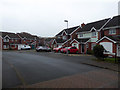
8
Lister Avenue, Harley-Bakewll
Seen from Fowler Avenue. Fowler Avenue is the main entrance road to this relatively small part of Warndon Villages.
Image: © Chris Allen
Taken: 22 Dec 2019
0.06 miles
9
Key Avenue, Harley-Bakewell
Seen from Fowler Avenue
Image: © Chris Allen
Taken: 24 Nov 2019
0.06 miles
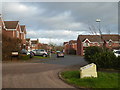
10
Attwood Place, Harley-Bakewell
Seen from Lister avenue. The streets in Harley-Bakewell appear to be named after indviduals but I don't know if there is a thread linking them all. The street name signs in Warndon Villages all indicate which subdivision they are in - this is Harley-Bakewell.
Image: © Chris Allen
Taken: 22 Dec 2019
0.06 miles