IMAGES TAKEN NEAR TO
Trotshill Lane West, WORCESTER, WR4 0HH
Introduction
This page details the photographs taken nearby to Trotshill Lane West, WR4 0HH by members of the Geograph project.
The Geograph project started in 2005 with the aim of publishing, organising and preserving representative images for every square kilometre of Great Britain, Ireland and the Isle of Man.

There are currently over 7.5m images from over14,400 individuals and you can help contribute to the project by visiting https://www.geograph.org.uk
Image Map
Images are licensed for reuse under creativecommons.org/licenses/by-sa/2.0
Notes
- Clicking on the map will re-center to the selected point.
- The higher the marker number, the further away the image location is from the centre of the postcode.
Image Listing (109 Images Found)
Images are licensed for reuse under creativecommons.org/licenses/by-sa/2.0
Image
Details
Distance
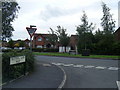
1
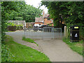
Public footpath approaching Trotshill Lane West, Worcester
Trotshill Lane is an old road submerged in the modern vastness of Warndon Villages. It has been cut into two sections and no longer goes anywhere apart from providing access to some of the older houses that predate the development.
Image: © Chris Allen
Taken: 15 Jun 2022
0.01 miles
2
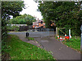
Path joining Trotshill Lane West, Worcester
The public footpath passes between modern developments in the Lyppards section of Warndon Villages and joins this old road which is one of the few things pre-dating this green field development.
Image: © Chris Allen
Taken: 25 Oct 2021
0.02 miles
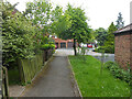
3

House off Trotshill Lane West
This lane is an old thoroughfare within the more recent development of Warndon Villages. This look like it might be a property pre-dating the later development but it can be hard to tell. The view is firmly from the public right of way although with a little zoom.
Image: © Chris Allen
Taken: 15 Dec 2019
0.05 miles
4
The end of Wood Leason Avenue, Lyppard-Hanford
The end of the cul-de-sac as seen from a short path linking it to a public footpath passing between two sections of the Lyppards development.
Image: © Chris Allen
Taken: 25 Oct 2021
0.05 miles
5
Great Oaty Gardens, Lyppard-Hanford, Worcester
A road in one of the subdivisions of Warndon Villages seen from a public footpath leading to Trotshill Lane West.
Image: © Chris Allen
Taken: 15 Jun 2022
0.05 miles
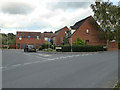
6
Trotshill Lane West/Slade Avenue junction
Image: © Colin Pyle
Taken: 18 Sep 2010
0.06 miles
7
Farundles Avenue, Lyppard-Woodgreen
From the junction with Debdale Avenue. Part of the Warndon Villages complex.
Image: © Chris Allen
Taken: 15 Dec 2019
0.06 miles
8
Junction of Trotshill Lane west and Slade Avenue
Trotshill Lane is an old, pre-existing thoroughfare in the midst of much new development. The photographer is looking across Slade Avenue that is part of the Lyppard-Hanford development.
Image: © Chris Allen
Taken: 6 Oct 2019
0.07 miles
9
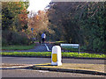
Woodgreen Drive, The Lyppards
Looking across the B4638 Woodgreen Drive to the path that leads to Trotshill Lane West. I have not walked that particular path at the time of posting. Warndon Villages contain many paths that link the various collections of houses that constitute this large housing development.
Image: © Chris Allen
Taken: 1 Dec 2019
0.07 miles
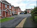
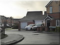
10
Slade Avenue, Warndon, Worcester
Winding suburban roads in a new housing development
Image: © David Smith
Taken: 8 Oct 2016
0.08 miles