IMAGES TAKEN NEAR TO
Menston Close, WORCESTER, WR4 0BB
Introduction
This page details the photographs taken nearby to Menston Close, WR4 0BB by members of the Geograph project.
The Geograph project started in 2005 with the aim of publishing, organising and preserving representative images for every square kilometre of Great Britain, Ireland and the Isle of Man.

There are currently over 7.5m images from over14,400 individuals and you can help contribute to the project by visiting https://www.geograph.org.uk
Image Map
Images are licensed for reuse under creativecommons.org/licenses/by-sa/2.0
Notes
- Clicking on the map will re-center to the selected point.
- The higher the marker number, the further away the image location is from the centre of the postcode.
Image Listing (115 Images Found)
Images are licensed for reuse under creativecommons.org/licenses/by-sa/2.0
Image
Details
Distance
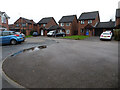
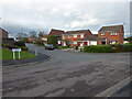
1
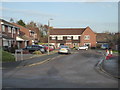
Menston Close
Seen from Wharfedale Drive in Warndon.
Image: © Chris Allen
Taken: 26 Nov 2019
0.02 miles
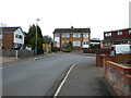
2
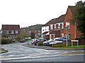
Wharfedale Drive seen across Tolladine Road, Worcester
Image: © Chris Allen
Taken: 20 Feb 2021
0.03 miles
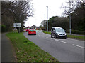
3
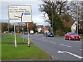
Road sign on the B4637, Worcester
Tolladine Road approaching Warndon Villages with Warndon and Blackpole off to the left.
Image: © Chris Allen
Taken: 21 Nov 2020
0.04 miles
4
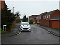
Burnsall Close from Grassington Drive, Warndon
The streets in this part of Warndon are all apparently named after places in Yorkshire while on the other side of the B4637 they are named after places in the Lake District.
Image: © Chris Allen
Taken: 20 Feb 2021
0.04 miles
5
The end of Grassington Drive, Warndon, Worcester
The roads in this part of the estate are all named after places in Yorkshire. Seen from the short path linking it to the B4637 Middle Hollow Drive.
Image: © Chris Allen
Taken: 20 Feb 2021
0.05 miles
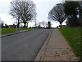
6
Middle Hollow Drive, Worcester
The B4637 from Warndon Villages to the city centre. The fork to the right is through Warndon estate to Blackpole.
Image: © Chris Allen
Taken: 23 Feb 2021
0.05 miles
7
Tolladine Road, Worcester
Somewhat paradoxically, Tolladine Road has a branch that is a cul-de sac and also called Tolladine Road on Google Maps. This is the cul-de-sac looking back towards the main road, which in turn turns-off itself and becomes a minor road from a B-road. All very confusing.
Image: © Chris Allen
Taken: 23 Feb 2021
0.06 miles
8
The junction of Threshfield Drive and Wharfedale Drive
In the Warndon area of Worcester.
Image: © Chris Allen
Taken: 26 Nov 2019
0.07 miles
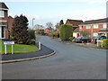
9
Three way junction, Warndon, Worcester
Three different street names are seen here. Threshfield Drive on the left joins Grassington Drive end on to the right and Wharfedale Drive is perpendicular in the centre.
Image: © Chris Allen
Taken: 21 Nov 2020
0.07 miles
10
The end of Scafell Close, Worcester
I wandered up this cul-de-sac on the off-chance I could make my escape on foot. The no cycling sigh left of centre marks a path to Tolladine Road, so I was indeed able to continue without retracing my steps.
Image: © Chris Allen
Taken: 23 Feb 2021
0.07 miles