IMAGES TAKEN NEAR TO
Friesland Close, WORCESTER, WR3 8QL
Introduction
This page details the photographs taken nearby to Friesland Close, WR3 8QL by members of the Geograph project.
The Geograph project started in 2005 with the aim of publishing, organising and preserving representative images for every square kilometre of Great Britain, Ireland and the Isle of Man.

There are currently over 7.5m images from over14,400 individuals and you can help contribute to the project by visiting https://www.geograph.org.uk
Image Map
Images are licensed for reuse under creativecommons.org/licenses/by-sa/2.0
Notes
- Clicking on the map will re-center to the selected point.
- The higher the marker number, the further away the image location is from the centre of the postcode.
Image Listing (74 Images Found)
Images are licensed for reuse under creativecommons.org/licenses/by-sa/2.0
Image
Details
Distance
1
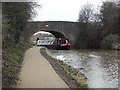
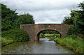
Ivy Bridge - Bridge No. 16, Worcester & Birmingham Canal
This bridge now provides access for dog walkers etc to the area beside Perdiswell Leisure Centre.
Image: © Chris Allen
Taken: 27 Mar 2010
0.02 miles
2
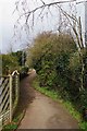
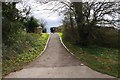
Footpath from Friesland Close to Worcester & Birmingham Canal, Worcester
The footpath is heading for bridge no. 16 of the Worcester & Birmingham Canal. From the bridge there are paths adjacent to the canal, and to Perdiswell Park.
Image: © P L Chadwick
Taken: 21 Feb 2016
0.03 miles
3
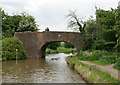
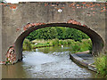
Bridge 16, Worcester and Birmingham Canal
Looking north.
Image: © Pierre Terre
Taken: 15 May 2009
0.04 miles
4
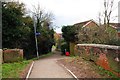
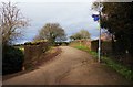
Footpath to Friesland Close, Worcester
This footpath crosses the Worcester & Birmingham Canal by bridge no. 16 and is seen here on its way to Friesland Close, part of a modern housing estate. The red bin is for dog waste.
Image: © P L Chadwick
Taken: 21 Feb 2016
0.04 miles
5
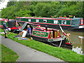
"The Jam Butty" on the Worcester and Birmingham Canal
This short narrowboat, named Montgomery, is used to sell homemade jams, hence "The Jam Butty". A butty is an unpowered narrow boat towed by another and this is unpowered as indicated by the large tiller. It was about to participate in a three day Waterways Festival in Worcester.
Image: © Chris Allen
Taken: 27 Aug 2021
0.04 miles
6
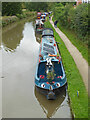
Worcester and Birmingham Canal, Worcester
Looking towards Birmingham from bridge No. 16. The boats are gathred for a Waterways Festival.
Image: © Chris Allen
Taken: 27 Aug 2021
0.04 miles
7
Worcester & Birmingham Canal bridge no. 16, Perdiswell, Worcester
The bridge now leads in this direction to Friesland Close, Drovers Way and other streets on a modern housing estate.
Image: © P L Chadwick
Taken: 21 Feb 2016
0.04 miles
8
Worcester & Birmingham Canal bridge no. 16, Perdiswell, Worcester
In this direction the bridge leads to a field adjacent to the canal, and further on to Perdiswell Park. It also gives access to the canal towpath.
Image: © P L Chadwick
Taken: 21 Feb 2016
0.04 miles
9
Ivy Bridge near Astwood in Worcester
Originally a farmer's accommodation bridge, Ivy Bridge (No 16) is now used as a public footpath between housing on the right and fields and a golf course to the left.
Image: © Roger D Kidd
Taken: 21 Aug 2010
0.04 miles
10
Ivy Bridge near Astwood in Worcester
Originally a farmer's accommodation bridge, Ivy Bridge (No 16) is now used as a public footpath between housing on the right and fields and a golf course to the left.
Image: © Roger D Kidd
Taken: 21 Aug 2010
0.04 miles