IMAGES TAKEN NEAR TO
Owen Close, WORCESTER, WR3 8DS
Introduction
This page details the photographs taken nearby to Owen Close, WR3 8DS by members of the Geograph project.
The Geograph project started in 2005 with the aim of publishing, organising and preserving representative images for every square kilometre of Great Britain, Ireland and the Isle of Man.

There are currently over 7.5m images from over14,400 individuals and you can help contribute to the project by visiting https://www.geograph.org.uk
Image Map
Images are licensed for reuse under creativecommons.org/licenses/by-sa/2.0
Notes
- Clicking on the map will re-center to the selected point.
- The higher the marker number, the further away the image location is from the centre of the postcode.
Image Listing (11 Images Found)
Images are licensed for reuse under creativecommons.org/licenses/by-sa/2.0
Image
Details
Distance
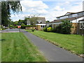
1
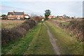
Sling Lane
Sling Lane approaching Fernhill Heath. This is a popular path between the village and Hindlip Hall which is the headquarters of the West Mercia Constabulary.
Image: © Philip Halling
Taken: 15 Jan 2012
0.07 miles
3
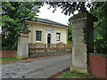
Lodge and gatepiers near Fernhill Heath
At the entrance to Image Dated c1818. Grade II listed.
Image: © Stephen Richards
Taken: 18 Jul 2014
0.08 miles
4
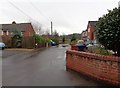
O'Keys Lane, Fernhill Heath, Worcestershire
The lane is odd shaped and this is the end furthest from the main road (A38).
Image: © Jeff Gogarty
Taken: 27 Dec 2015
0.13 miles
5
Buildings on Oakey Farm, Fernhill Heath, Worcestershire
Taken from the end of O'Keys Lane.
Image: © Jeff Gogarty
Taken: 27 Dec 2015
0.17 miles
6
Fernhill Heath - Pine Close
From the footpath which provides a shortcut to Fir Tree Road.
Image: © Peter Whatley
Taken: 23 Jun 2008
0.18 miles
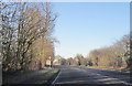
7
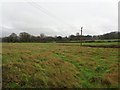
Field off O'Keys Lane, Fernhill Heath, Worcestershire
This is looking towards the West Mercia Police Headquarters at Hindlip. The transmission mast just pokes above the trees and just can be made out a large image.
Image: © Jeff Gogarty
Taken: 27 Dec 2015
0.19 miles
8
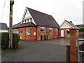
Fernhill Heath Baptist Church, O'Keys Lane
Image: © Jeff Gogarty
Taken: 27 Dec 2015
0.19 miles
9
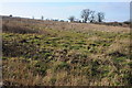
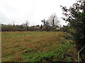
Rough grassland at Fernhill Heath
This field of rough grazing lies between the village of Fernhill Heath on the A38 and Hindlip Hall which is accommodated by the West Mercia Constabulary headquarters. Here the field is viewed from Sling Lane, a footpath connecting Fernhill Heath with Hindlip.
Image: © Philip Halling
Taken: 15 Jan 2012
0.20 miles
10
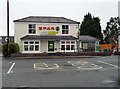
Another ex-pub, Fernhill Heath, Worcestershire
This Spa shop was the Halfway House public house until very recently.
Image: © Jeff Gogarty
Taken: 27 Dec 2015
0.22 miles