IMAGES TAKEN NEAR TO
Broadway Grove, WORCESTER, WR2 5EY
Introduction
This page details the photographs taken nearby to Broadway Grove, WR2 5EY by members of the Geograph project.
The Geograph project started in 2005 with the aim of publishing, organising and preserving representative images for every square kilometre of Great Britain, Ireland and the Isle of Man.

There are currently over 7.5m images from over14,400 individuals and you can help contribute to the project by visiting https://www.geograph.org.uk
Image Map
Images are licensed for reuse under creativecommons.org/licenses/by-sa/2.0
Notes
- Clicking on the map will re-center to the selected point.
- The higher the marker number, the further away the image location is from the centre of the postcode.
Image Listing (85 Images Found)
Images are licensed for reuse under creativecommons.org/licenses/by-sa/2.0
Image
Details
Distance
1
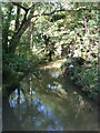
The Laugherne Brook
Seen from a bridge on a public footpath from the A44 to Dines Green.
Image: © Chris Allen
Taken: 29 Sep 2012
0.07 miles
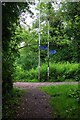
2
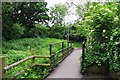
Footbridge over Laughern Brook, St. John's, Worcester
Looking in the direction of the centre of St. John's (which is a long walk from here).
Image
Image: © P L Chadwick
Taken: 2 Jun 2018
0.07 miles
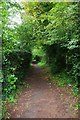
3
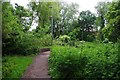
Public footpath approaching footbridge over Laughern Brook, St. John's, Worcester
The path goes to Greenacres Road on the Dines Green housing estate. Just before the low wall on the left, another public footpath goes left to a pedestrian level crossing over the railway and on to Bromyard Road.
Image: © P L Chadwick
Taken: 2 Jun 2018
0.08 miles
4
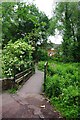
Footbridge over Laughern Brook, St. John's, Worcester
The footbridge carries a public footpath to Dines Green via Greenacres Road.
Image
Image: © P L Chadwick
Taken: 2 Jun 2018
0.08 miles
5
Junction of public footpaths, St. John's, Worcester
The path behind the camera position has come from the railway pedestrian level crossing and Bromyard Road. The sign for the path going to the left reads: "Dines Green via Greenacres Road". Dines Green is a mixed area of social housing and privately owned housing. The sign for the path going to the right reads: "Meco Alley St John's Centre".
Image: © P L Chadwick
Taken: 2 Jun 2018
0.08 miles
6
Public footpath on north side of pedestrian level crossing, St. John's, Worcester
The path later joins others serving various housing estates and a cemetery.
Image: © P L Chadwick
Taken: 2 Jun 2018
0.10 miles
7

Meco Alley, St. John's, Worcester
This section of public footpath is known as Meco Alley. There are some very widely spaced steps, a couple of which can be seen in the distance in this view. The path leads to the centre of the St. John's area, as well as housing developments and a cemetery.
Image: © P L Chadwick
Taken: 2 Jun 2018
0.11 miles
8
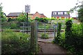
Kissing gate at entrance to pedestrian level crossing, St. John's, Worcester
The sign reads: "Stop Look Listen Beware of trains". Great care is needed here because the crossing is not protected by lights or barriers and the railway is double track. At least on this side there is a kissing gate to pass through, so children cannot run onto the tracks. Strangely, and rather alarmingly, there is no gate on the other side. The passageway from Bromyard Road runs straight onto the level crossing over the tracks.
Image
Image: © P L Chadwick
Taken: 2 Jun 2018
0.12 miles
9
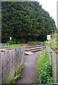
Passageway to pedestrian level crossing, St. John's, Worcester
The signs on each side of the crossing say "Stop Look Listen Beware of trains". Great care is needed here, as the railway is double track and there are no lights or barriers protecting the crossing. Also, as you can see, the passageway runs straight onto the level crossing. There is no barrier whereas on the other side there is a fence and kissing gate to pass through.
Image
Image
Image: © P L Chadwick
Taken: 2 Jun 2018
0.12 miles
10
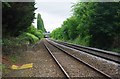
Railway tracks at St. John's, looking in the direction of Foregate Street Station, Worcester
Photographed from the side of the pedestrian level crossing.
Image: © P L Chadwick
Taken: 2 Jun 2018
0.12 miles