IMAGES TAKEN NEAR TO
Mount Orchard, TENBURY WELLS, WR15 8DW
Introduction
This page details the photographs taken nearby to Mount Orchard, WR15 8DW by members of the Geograph project.
The Geograph project started in 2005 with the aim of publishing, organising and preserving representative images for every square kilometre of Great Britain, Ireland and the Isle of Man.

There are currently over 7.5m images from over14,400 individuals and you can help contribute to the project by visiting https://www.geograph.org.uk
Image Map
Images are licensed for reuse under creativecommons.org/licenses/by-sa/2.0
Notes
- Clicking on the map will re-center to the selected point.
- The higher the marker number, the further away the image location is from the centre of the postcode.
Image Listing (54 Images Found)
Images are licensed for reuse under creativecommons.org/licenses/by-sa/2.0
Image
Details
Distance
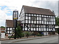
4

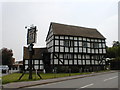
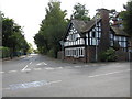
Pembroke House Inn
Delightfully wonky 16th century inn at the junction of the roads to Bromyard and Leominster.
Image: © Philip Pankhurst
Taken: 10 Aug 2013
0.11 miles
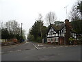
6
Tenbury Wells - Start Of Bromyard Road
Image: © Peter Whatley
Taken: 9 Sep 2009
0.11 miles
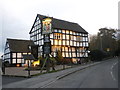
7
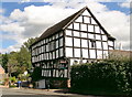
Pembroke House Inn, Tenbury Wells
Delightfully wonky medieval inn at the top of Cross Street.
Image: © Philip Pankhurst
Taken: 10 Aug 2013
0.11 miles
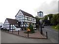
8
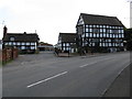
Pembroke Cottage & Pembroke House Inn
Between the two venerable buildings is an access road to Tenbury Wells Primary School, this latter just being visible in the distance.
Image: © Peter Whatley
Taken: 9 Sep 2009
0.11 miles
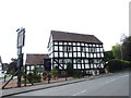
10
Pembroke House, Tenbury Wells
Once the site of a Tollhouse, Pembroke House was built as a farmhouse in the 16th century; by the year 1600 it was a cider house and now functions as an inn/restaurant.
Image: © Richard Rogerson
Taken: 30 Jul 2016
0.12 miles