IMAGES TAKEN NEAR TO
Benbow Close, MALVERN, WR14 4JJ
Introduction
This page details the photographs taken nearby to Benbow Close, WR14 4JJ by members of the Geograph project.
The Geograph project started in 2005 with the aim of publishing, organising and preserving representative images for every square kilometre of Great Britain, Ireland and the Isle of Man.

There are currently over 7.5m images from over14,400 individuals and you can help contribute to the project by visiting https://www.geograph.org.uk
Image Map
Images are licensed for reuse under creativecommons.org/licenses/by-sa/2.0
Notes
- Clicking on the map will re-center to the selected point.
- The higher the marker number, the further away the image location is from the centre of the postcode.
Image Listing (139 Images Found)
Images are licensed for reuse under creativecommons.org/licenses/by-sa/2.0
Image
Details
Distance
1
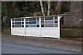
Bus shelter on Wells Road
Bus shelter on Wells Road at Malvern Wells.
Image: © Philip Halling
Taken: 13 Dec 2021
0.02 miles
2
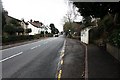
Bus shelter on the Wells Road
Looking up the Wells Road from near the junction with the Hanley Road.
Image: © Bob Embleton
Taken: 26 Mar 2010
0.04 miles
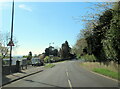
4
Hanley Road junction
The Hanley road starts here at its junction with the A449 Wells Road.
Image: © Bob Embleton
Taken: 26 Mar 2010
0.06 miles
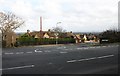
5
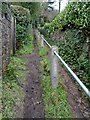
Footpath to Hollywell Road
Footpath between Wells Road and Hollywell Road.
Image: © Philip Halling
Taken: 6 Feb 2021
0.07 miles
6
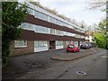
Halas House
Apartments dating from the late 1960s or early 1970s on Holywell Road in Malvern Wells.
Image: © Philip Halling
Taken: 21 Mar 2020
0.08 miles
7
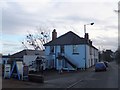
Former hotel (Hornyold Arms) in Malvern Wells
The hotel has now been converted into apartments
Image: © David Smith
Taken: 13 Jan 2014
0.08 miles
8
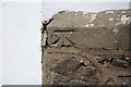
Detail of Benchmark
On the sandstone cap of the Malvern granite wall attached to the south-western corner of Hornyold Apartments.
Image
Image
Image: © Bob Embleton
Taken: 26 Mar 2010
0.09 miles
9
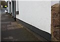
Western side of Hornyold Apartments
Showing the Malvern granite wall with its benchmark at the south western corner of the building.
Image
Image
Image: © Bob Embleton
Taken: 26 Mar 2010
0.09 miles
10
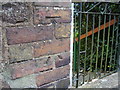
Nineteenth-century benchmark on wall
The 1886-93 map shows this benchmark at 437.8 ft. above sea level (Liverpool datum) on the west face of wall, 3m south of Hornyold Arms Hotel (now a private house). The two parts of this benchmark have been separate during rebuilding of the wall.
Image: © Shantavira
Taken: 17 Oct 2015
0.09 miles