IMAGES TAKEN NEAR TO
Park Road, MALVERN, WR14 4BJ
Introduction
This page details the photographs taken nearby to Park Road, WR14 4BJ by members of the Geograph project.
The Geograph project started in 2005 with the aim of publishing, organising and preserving representative images for every square kilometre of Great Britain, Ireland and the Isle of Man.

There are currently over 7.5m images from over14,400 individuals and you can help contribute to the project by visiting https://www.geograph.org.uk
Image Map (Loading...)


Getting Data...Please wait
Leaflet Map data © OpenStreetMap
Images are licensed for reuse under creativecommons.org/licenses/by-sa/2.0
Notes
- Clicking on the map will re-center to the selected point.
- The higher the marker number, the further away the image location is from the centre of the postcode.
Image Listing (116 Images Found)
Images are licensed for reuse under creativecommons.org/licenses/by-sa/2.0
Image
Details
Distance
1
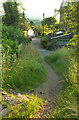
Lower Dingle, West Malvern
In the foreground a path with steps drops from the B4232 to meet the road, which is followed by West Malvern footpath 534(C). The white building is the Brewers Arms, shown at Image
Image: © Derek Harper
Taken: 14 Jul 2021
0.05 miles
2
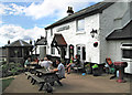
Outdoor seating at the Brewers Arms, West Malvern
Image: © Dave Croker
Taken: 18 Aug 2012
0.06 miles
3
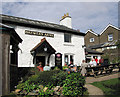
The Brewers Arms, West Malvern
It's very easy to include a walk to this pub with the Worcestershire Beacon!
Image: © Dave Croker
Taken: 18 Aug 2012
0.06 miles
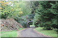
4
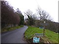
Track to The Dingle, West Malvern
A bridleway leading to the saddle between the Worcestershire Beacon and Sugarloaf Hill
Image: © David Smith
Taken: 30 Dec 2015
0.06 miles
5
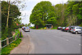
Malvern Hills District : West Malvern Road
On the road below the top of the Malvern Hills.
Image: © Lewis Clarke
Taken: 5 May 2014
0.07 miles
6
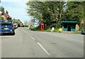
B4232 West Malvern Road with telephone box and bus shelter
Image: © Roy Hughes
Taken: 24 Apr 2021
0.07 miles
7
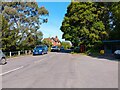
West Malvern Road (B4232)
Looking from Dingle Car Park at West Malvern Road (the B4232).
Image: © Oscar Taylor
Taken: 21 May 2023
0.08 miles
8
The Quabbs bridge
The bridge carries the track known as The Quabbs over the track through the gardens once belonging to Lady Howard de Walden.
Image: © Bob Embleton
Taken: 21 Oct 2010
0.08 miles
9
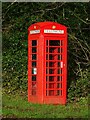
A K6 telephone box
A K6 telephone box on West Malvern Road. This telephone box is probably Sir Giles Gilbert Scott's most famous design, despite famous buildings such as Liverpool Anglican Cathedral and Battersea Power Station which were also his work.
Image: © Philip Halling
Taken: 19 Dec 2020
0.08 miles
10
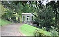
Summer house, Lady Howard de Walden's Mansion
In the grounds of what was the mansion for Lady Howard de Walden.
The mansion later became St James's, a girls' school.
Lord and Lady Baden-Powell, the founders of the Scout and Guide movements sent their daughters to the school.
It is said Baden-Powell slept in this building when visiting his daughters.
Image: © Bob Embleton
Taken: 21 Oct 2010
0.10 miles