IMAGES TAKEN NEAR TO
Moorlands Road, MALVERN, WR14 2UB
Introduction
This page details the photographs taken nearby to Moorlands Road, WR14 2UB by members of the Geograph project.
The Geograph project started in 2005 with the aim of publishing, organising and preserving representative images for every square kilometre of Great Britain, Ireland and the Isle of Man.

There are currently over 7.5m images from over14,400 individuals and you can help contribute to the project by visiting https://www.geograph.org.uk
Image Map (Loading...)


Getting Data...Please wait
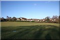
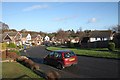
Leaflet Map data © OpenStreetMap
Images are licensed for reuse under creativecommons.org/licenses/by-sa/2.0
Notes
- Clicking on the map will re-center to the selected point.
- The higher the marker number, the further away the image location is from the centre of the postcode.
Image Listing (96 Images Found)
Images are licensed for reuse under creativecommons.org/licenses/by-sa/2.0
Image
Details
Distance
1
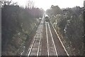
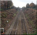
Railway line to Great Malvern
Looking south (near mid-day) from the Moorlands Road railway bridge towards Great Malvern station.
The train is about halfway between Great Malvern and Malvern Link - only a two minute journey - and is probably decelerating.
Notice the left hand line is still supported by the old wooden sleepers whereas the other has been modernised with concrete replacements.
Image: © Bob Embleton
Taken: 6 Dec 2009
0.01 miles
2
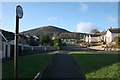
Cul-de-sac off Meadow Road, Malvern
A small spur of Meadow Road to make use of the available building land up to the railway line.
North Hill is in the distance.
Image: © Bob Embleton
Taken: 6 Dec 2009
0.05 miles
3
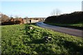
Moorlands Road railway bridge
Looking from Malvern Link common on the western side of the railway line.
Notice the chunks of Malvern granite on the verge to deter motorists from driving over the common.
Image: © Bob Embleton
Taken: 6 Dec 2009
0.06 miles
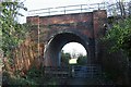
4
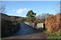
Moorlands Road railway bridge
The bridge takes Moorlands Road over the Malvern to Worcester railway.
Looking towards the quarried Malvern Hills.
The original narrow bridge dates from the Victorian times when the land here was common or fields.
Image: © Bob Embleton
Taken: 6 Dec 2009
0.06 miles
5
Field south of Meadow Rise
The field has the railway embankment on its west side, Meadow Rise to the north and the Grove School to the east.
There are more fields to the south all of which may soon be developed for housing.
Image: © Bob Embleton
Taken: 6 Dec 2009
0.06 miles
6
Railway cutting south of Malvern Link railway station
Viewed from the Worcester Road wall here http://www.geograph.org.uk/photo/4276311 looking south towards Moorlands Road bridge.
Image: © Jaggery
Taken: 29 Nov 2014
0.07 miles
7
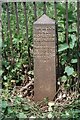
Old Boundary Marker by the Grove School, Malvern
Estate Boundary Marker by the railings of the Grove School. Malvern parish. Cockshute Farm Estate was acquired in 1658 by Sir George Strode and he donated the income to the parish church and poor hospital of St. James in Clerkenwell, London. The posts were erected in the mid-1800s to mark the boundary of the estate. 25 were shown on a map of 1884 and many survive in gardens as the estate has been developed for housing. Grade II Listed details https://historicengland.org.uk/listing/the-list/list-entry/1349464.
Milestone Society National ID: WO_CLERK06em
Image: © J Scrine
Taken: 15 Feb 2011
0.07 miles
8
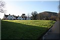
Moorlands Road
Semi detached houses on the edge of Malvern Link common.
North Hill in the distance.
Image: © Bob Embleton
Taken: 6 Dec 2009
0.08 miles
9
Meadow Road
Detached private housing estate from the 1970s.
From the name of the road this once all meadows farmed by Link Farm.
Image: © Bob Embleton
Taken: 6 Dec 2009
0.10 miles
10
Old railway bridge
Narrow passageway giving access to fields behind the Grove School.
Image: © Bob Embleton
Taken: 6 Dec 2009
0.10 miles