IMAGES TAKEN NEAR TO
Kingshill Close, MALVERN, WR14 2BP
Introduction
This page details the photographs taken nearby to Kingshill Close, WR14 2BP by members of the Geograph project.
The Geograph project started in 2005 with the aim of publishing, organising and preserving representative images for every square kilometre of Great Britain, Ireland and the Isle of Man.

There are currently over 7.5m images from over14,400 individuals and you can help contribute to the project by visiting https://www.geograph.org.uk
Image Map (Loading...)


Getting Data...Please wait
Leaflet Map data © OpenStreetMap
Images are licensed for reuse under creativecommons.org/licenses/by-sa/2.0
Notes
- Clicking on the map will re-center to the selected point.
- The higher the marker number, the further away the image location is from the centre of the postcode.
Image Listing (204 Images Found)
Images are licensed for reuse under creativecommons.org/licenses/by-sa/2.0
Image
Details
Distance
1
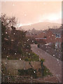
Bank Holiday Snow Shower at Fernhill Grove - 1
View south-west towards the Worcester Beacon. As dusk falls yet another snow shower arrives, driven by strong northerly winds. Yes, the Easter holidays are here!
Image: © Trevor Rickard
Taken: 22 Mar 2008
0.02 miles
2
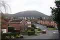
Greenhill Drive, Malvern
A 1980s residential development infilling the green fields below the railway line. In the distance is North Hill with the large 18th century town houses on Worcester Road and the TV & Radio transmitter.
Image: © Bob Embleton
Taken: 23 Feb 2007
0.03 miles
3
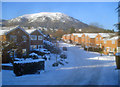
Greenhill Drive in the snow
Looking north with fog obscuring the Malvern Hills. Yes, the potted palm did survive the winter.
Image: © Trevor Rickard
Taken: 6 Feb 2009
0.04 miles
4
Greenhill Drive in the snow
View west to North Hill. Following heavy snow falls, only four-wheel-drive vehicles are getting up this road. Being off the main roads, there is no grit spreading here.
Image: © Trevor Rickard
Taken: 8 Jan 2010
0.04 miles
5
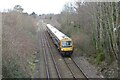
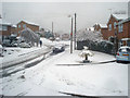
Train approaching Great Malvern
Train approaching Great Malvern station, viewed here from the bridge carrying Madresfield Road.
Image: © Philip Halling
Taken: 24 Feb 2023
0.06 miles
6
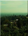
Panorama
View from Worcester Road to the east
Image: © Deborah Tilley
Taken: 26 Sep 2012
0.07 miles
7
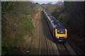
Train approaching Great Malvern
Seen from Madresfield Road bridge, a First Great Western HST approaches Great Malvern station with a London - Hereford service.
Image: © Stephen McKay
Taken: 9 Dec 2011
0.08 miles
8
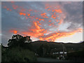
Sunset over the Worcestershire Beacon
View west from Madresfield Road. We've called this one the 'volcano sunset' as it appears to be spewing out of the top of the hill.
Image: © Trevor Rickard
Taken: 16 Sep 2010
0.08 miles
9
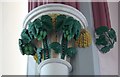
Capital, Lansdowne Methodist Church, Malvern
Hidden under layers of cream paint for decades, the detail was only recently revealed to show the local produce of wheat and hops. The latter only having a use prohibited by the teetotal Methodists.
Image]
Image: © Bob Embleton
Taken: 25 Jun 2011
0.08 miles
10
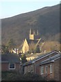
Fernhill Grove and Lansdowne Church
View to the south-west with the houses of Fernhill Grove in the foreground, Lansdowne Church in the middle distance and the slopes of the Worcestershire Beacon behind.
Image: © Trevor Rickard
Taken: 11 Dec 2007
0.08 miles