IMAGES TAKEN NEAR TO
Vinesend Lane, MALVERN, WR13 5NH
Introduction
This page details the photographs taken nearby to Vinesend Lane, WR13 5NH by members of the Geograph project.
The Geograph project started in 2005 with the aim of publishing, organising and preserving representative images for every square kilometre of Great Britain, Ireland and the Isle of Man.

There are currently over 7.5m images from over14,400 individuals and you can help contribute to the project by visiting https://www.geograph.org.uk
Image Map
Images are licensed for reuse under creativecommons.org/licenses/by-sa/2.0
Notes
- Clicking on the map will re-center to the selected point.
- The higher the marker number, the further away the image location is from the centre of the postcode.
Image Listing (42 Images Found)
Images are licensed for reuse under creativecommons.org/licenses/by-sa/2.0
Image
Details
Distance
1
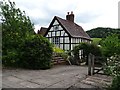
Timber-framed cottage
Timber-framed house at Lower Vinesend near Cradley.
Image: © Philip Halling
Taken: 27 May 2019
0.01 miles
2
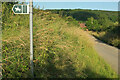
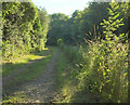
Sabrina Way leaves lane, Vinesend
The bridleway is Cradley CD43. The lane is a no through road to Upper Vinesend Farm.
Image: © Derek Harper
Taken: 13 Jul 2021
0.02 miles
3
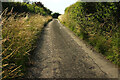
Sabrina Way near Lower Vinesend Farm
Looking right from Image] towards Vinesend House.
Image: © Derek Harper
Taken: 13 Jul 2021
0.03 miles
4
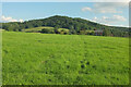
Sabrina Way
Following Cradley bridleway CD43 across the field shown in Image], with Vinesend House right of centre and High Grove Wood rising in the background.
Image: © Derek Harper
Taken: 13 Jul 2021
0.07 miles
5
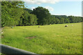
Sheep, Lower Vinesend Farm
From the Sabrina Way. The trees along the field boundary hide the farm buildings shown in Image
Image: © Derek Harper
Taken: 13 Jul 2021
0.07 miles
6
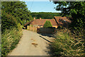
Lower Vinesend Farm
Image: © Derek Harper
Taken: 13 Jul 2021
0.07 miles
7
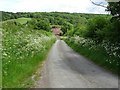
Country road near Cradley
Country road approaching Lower Vinesend Farm near Cradley.
Image: © Philip Halling
Taken: 27 May 2019
0.08 miles
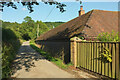
8
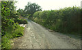
Lane past Lower Vinesend Farm
Looking in the other direction from Image
Image: © Derek Harper
Taken: 13 Jul 2021
0.08 miles
9
Path towards Cradley
Cradley footpath CD42 seen looking the other way from Image], again from the Sabrina Way crossing it.
Image: © Derek Harper
Taken: 13 Jul 2021
0.08 miles
10
Roof, Lower Vinesend Farm
Of a converted barn beside the Sabrina Way.
Image: © Derek Harper
Taken: 13 Jul 2021
0.09 miles