IMAGES TAKEN NEAR TO
Sycamore Drive, EVESHAM, WR11 7AE
Introduction
This page details the photographs taken nearby to Sycamore Drive, WR11 7AE by members of the Geograph project.
The Geograph project started in 2005 with the aim of publishing, organising and preserving representative images for every square kilometre of Great Britain, Ireland and the Isle of Man.

There are currently over 7.5m images from over14,400 individuals and you can help contribute to the project by visiting https://www.geograph.org.uk
Image Map (Loading...)


Getting Data...Please wait
Leaflet Map data © OpenStreetMap
Images are licensed for reuse under creativecommons.org/licenses/by-sa/2.0
Notes
- Clicking on the map will re-center to the selected point.
- The higher the marker number, the further away the image location is from the centre of the postcode.
Image Listing (39 Images Found)
Images are licensed for reuse under creativecommons.org/licenses/by-sa/2.0
Image
Details
Distance
1
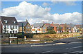
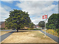
Sycamore Drive, Honeybourne
New houses near to Honeybourne Station.
Image: © Des Blenkinsopp
Taken: 24 Jul 2018
0.03 miles
2
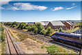
New housing by the station
Looking SSE from the Buckle Street road bridge over the railway.
The stationary train pictured is a First Great Western, most of which is standing in the relatively short Honeybourne Station, just the other side of the bridge.
A new housing estate is nearing completion just beyond the railway.
Image: © David P Howard
Taken: 23 Aug 2016
0.05 miles
3
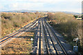
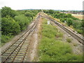
Honeybourne railway lines
A view from the bridge looking East , this is the line from Worcester to Oxford.Part of this line has been re-doubled to provide more train paths after the line was rationalized in the late 1960s with large sections becoming single line.
Image: © roger geach
Taken: 1 Dec 2012
0.06 miles
4
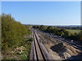
Lines south
The view from the bridge carrying Buckle Street over the railway in Honeybourne, looking southeast. The recently redoubled London to Worcester main lines are to the right. The line on the left leads to Central Engineer Park, the government storage depot at Long Marston. This line will also serve the preserved Gloucestershire Warwickshire Railway.
Image: © Michael Dibb
Taken: 15 Oct 2011
0.06 miles
5
Honeybourne Station Sign
The approach to Honeybourne Station along Stephenson Way.
Image: © Des Blenkinsopp
Taken: 24 Jul 2018
0.07 miles
6
Cotswold line at Honeybourne
View of the track to the east of the railway bridge near Honeybourne Station.
Image: © Philip Halling
Taken: 24 Jul 2010
0.08 miles
7
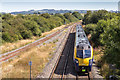
Train approaches Honeybourne Station
A First Great Western train approaches Honeybourne from the ESE.
Taken from the Buckle Street road bridge over the railway.
Image: © David P Howard
Taken: 23 Aug 2016
0.09 miles
8
Railway bridge at Honeybourne Station
Honeybourne Station used to be a junction of the Cotswold line and Cheltenham to Stratford line, however, the latter closed in the 1970s. As can be seen here at the time of the picture much of the Cotswold line, connecting Worcester with Oxford, was a single line, however, since this picture was taken much of this line has been upgraded to a dual track.
Image: © Philip Halling
Taken: 19 Jul 2008
0.11 miles
9

East from bridge 101-56
The track on the right is the main line to Oxford.
On the left is the remnants of the line leading to the junction with the Stratford to Cheltenham line. This continues as far as the former MoD base at Long Marston.
Image: © Jennifer Luther Thomas
Taken: 15 Jan 2007
0.11 miles
10
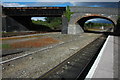
Over the lines
Buckle Street ascends gently to cross the London to Worcester main line railway at the narrow bridge controlled by traffic lights.
Image: © Michael Dibb
Taken: 15 Oct 2011
0.11 miles