IMAGES TAKEN NEAR TO
Simon De Montfort Drive, EVESHAM, WR11 4NR
Introduction
This page details the photographs taken nearby to Simon De Montfort Drive, WR11 4NR by members of the Geograph project.
The Geograph project started in 2005 with the aim of publishing, organising and preserving representative images for every square kilometre of Great Britain, Ireland and the Isle of Man.

There are currently over 7.5m images from over14,400 individuals and you can help contribute to the project by visiting https://www.geograph.org.uk
Image Map
Images are licensed for reuse under creativecommons.org/licenses/by-sa/2.0
Notes
- Clicking on the map will re-center to the selected point.
- The higher the marker number, the further away the image location is from the centre of the postcode.
Image Listing (14 Images Found)
Images are licensed for reuse under creativecommons.org/licenses/by-sa/2.0
Image
Details
Distance
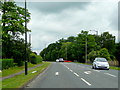
1
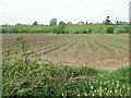
Simon De Montfort Drive
This road in the Greenhill area of Evesham is named after Simon De Montfort who was killed at the nearby battlefield in 1265.
Image: © Philip Halling
Taken: 17 Jan 2022
0.09 miles
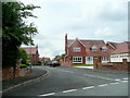
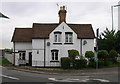
2
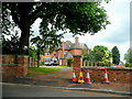
The Gables
A substantial red-brick property on Greenhill Park Road, Evesham.
Image: © Jonathan Billinger
Taken: 7 Jun 2010
0.10 miles
3
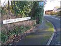
Blayney's Lane, Greenhill
A dead-end lane and footpath leading east to the River Avon.
Image: © Jonathan Billinger
Taken: 7 Jun 2010
0.13 miles
4
A4184 at Greenhill, Evesham
The old A435 looking north towards Bidford and Alcester.
Image: © Jonathan Billinger
Taken: 7 Jun 2010
0.16 miles
5
Prince Henry's Close, Evesham
A newly-developed cul-de-sac off Greenhill Park Road.
Image: © Jonathan Billinger
Taken: 7 Jun 2010
0.17 miles
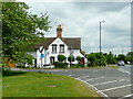
6
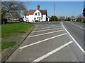
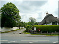
Former Tollhouse
Former Tollhouse at Greenhill on the A4184
Image: © Philip Halling
Taken: 4 Apr 2021
0.17 miles
7
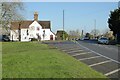
House beside the A4184
House beside the A4184 at Greenhill in Evesham. The house stands on what used to be the junction of the road to Worcester with the former A49. The road to the left is now a no through road.
Image: © Philip Halling
Taken: 17 Jan 2022
0.18 miles
8
Pike Cottages, Twyford Bank
This used to be the busy intersection of the A44 and A46 north of Evesham, before relief roads were constructed.
Image: © Jonathan Billinger
Taken: 7 Jun 2010
0.18 miles
9
Old Toll House by Green Hill, Twyford
Battlewell Toll House by the A4184 (was A435), in parish of Evesham (Wychavon District), Turnpike Cottage, Green Hill, Twyford, WR11 4TP.
Surveyed
Milestone Society National ID: WO.EVE
Image: © Alan Rosevear
Taken: Unknown
0.18 miles