IMAGES TAKEN NEAR TO
Harvey Street, WIGAN, WN3 4SF
Introduction
This page details the photographs taken nearby to Harvey Street, WN3 4SF by members of the Geograph project.
The Geograph project started in 2005 with the aim of publishing, organising and preserving representative images for every square kilometre of Great Britain, Ireland and the Isle of Man.

There are currently over 7.5m images from over14,400 individuals and you can help contribute to the project by visiting https://www.geograph.org.uk
Image Map
Images are licensed for reuse under creativecommons.org/licenses/by-sa/2.0
Notes
- Clicking on the map will re-center to the selected point.
- The higher the marker number, the further away the image location is from the centre of the postcode.
Image Listing (358 Images Found)
Images are licensed for reuse under creativecommons.org/licenses/by-sa/2.0
Image
Details
Distance
1
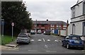
Hardacre Street, Ince-in-Makerfield
From Warrington Road along Hardacre Street past speed bumps towards Harvey Street.
The Rock Ferry Inn http://www.geograph.org.uk/photo/5549313 is on the right.
Image: © Jaggery
Taken: 23 Sep 2017
0.02 miles
2
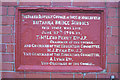
Foundation Stone, Britannia Bridge School
The building is 100 years old in 2006
Image: © David Long
Taken: 22 Dec 2005
0.02 miles
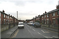
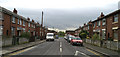
4
White cars on an Ince corner
Parked on the Harvey Street side of the Winifred Street corner in September 2017. Although silver remains the most popular car colour in the UK (at more than 20% of the total), in 2015 white was the most popular colour for new cars, with more than half a million new white car registrations.
Image: © Jaggery
Taken: 23 Sep 2017
0.02 miles
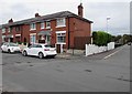
5
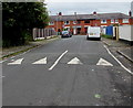
Hardacre Street speed bumps, Ince
Painted white triangles draw attention to the bumps near the Warrington Road junction.
Harvey Street houses are in the background.
Image: © Jaggery
Taken: 23 Sep 2017
0.02 miles
6
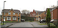
Kellaston Close, Lower Ince
The rear of Britannia Bridge Primary School is visible at the back. In the centre is a stone wall along the school yard perimeter - known as 'the blackie' because it was always black with soot from the steam engines in the sheds which once stood here.
Image: © David Long
Taken: 23 Feb 2007
0.03 miles
7
Harvey Street, Lower Ince
Named after the owner of the Bakery which occupied the site on the right at the bottom of the street.
Image: © David Long
Taken: 24 Apr 2007
0.03 miles
8
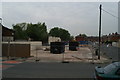
Gone
By Friday, May 9th the former Dairy and Bakery on the corner of Harvey Street (named after the Baker) and Manley Street had been demolished. Skips lie waiting to receive the last of the rubble. The site is earmarked for housing.
Image: © David Long
Taken: 9 May 2008
0.03 miles
9
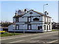
The Rock Ferry Inn
The Rock Ferry Inn, a public house at the corner of Hardacre Street and Warrington Road (A573).
Image: © David Dixon
Taken: 28 Mar 2012
0.03 miles
10
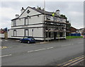
Rock Ferry Inn, Ince-in-Makerfield
Scaffolding is on the Warrington Road side of the pub on the corner of Hardacre Street in late September 2017.
Image: © Jaggery
Taken: 23 Sep 2017
0.03 miles